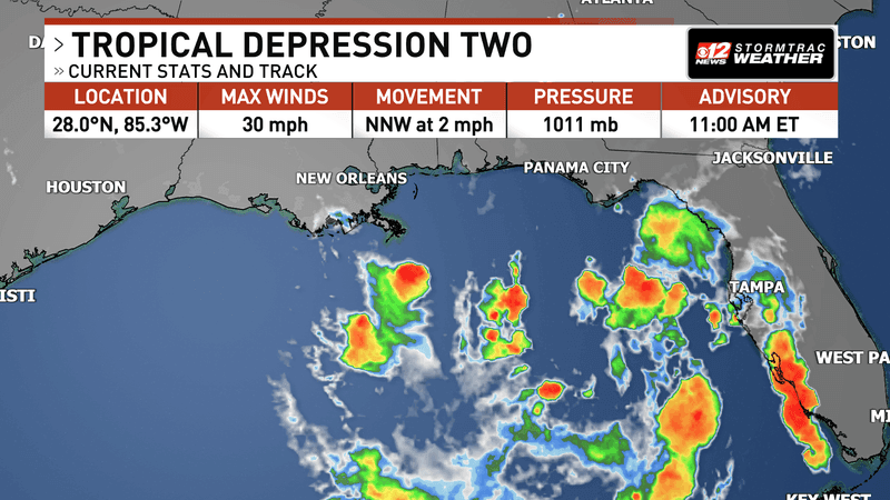
Tropical Depression 9 has formed in the western Gulf of Mexico, marking a significant development that meteorologists warn could lead to the first hurricane of the 2026 Atlantic season.
Key Takeaways
- system Status: Tropical Depression 9 (formerly Invest 92L) has achieved a closed circulation in the western Gulf of Mexico.
- Potential Intensification: The system is forecast to become Tropical storm Isaias by Tuesday night or Wednesday morning and could reach hurricane strength by Thursday.
- Landfall Forecast: A potential landfall window is projected between Friday, October 9, and Saturday, October 10, along the Gulf Coast, ranging from Louisiana to the Florida Panhandle.
- Primary Hazards: Key threats include heavy rainfall (up to 10 inches locally), storm surge, gusty winds, and isolated tornadoes.
- Texas Impact: While most models suggest the system will stay east of Texas, coastal flooding and rip currents are expected for parts of the Texas coastline.
- Seasonal Context: If it reaches hurricane status, Isaias will be the first hurricane of an otherwise relatively quiet 2026 season.
- Monitor Forecasts: Check the National Hurricane Center regularly for updates on the storm’s name, strength, and exact track.
- Prepare for Outages: Intense winds and heavy rain can lead to power outages lasting from several hours to multiple days. Ensure you have necessary supplies, including flashlights and backup power.
- Finalize Plans: If you are in a flood-prone or low-lying area, ensure your hurricane contingency plans are in place.
- Watch the Water: Be aware of coastal flood advisories and the potential for blocked roads on barrier islands.
- Ocean Safety: Avoid swimming in coastal waters due to the increased risk of dangerous rip currents.
- Flood Vigilance: The greatest threat to your area may be water rather than wind. Monitor local weather reports for flash flood warnings.
- Travel Safety: Avoid driving through flooded roadways. As the system moves inland, heavy rain can create sudden, life-threatening conditions on highways and local roads.
- Wednesday, October 8, 2026: The National Hurricane Center has tentatively scheduled the first low-level hurricane hunter flight into the system. These aircraft will fly directly into the storm to collect real-time data on wind speeds and central pressure, which will significantly improve the accuracy of the forecast.
- Thursday, October 9, 2026: This is the projected window for the system to reach hurricane strength.
- Friday, October 10 – Saturday, October 11, 2026: The primary window for potential landfall along the Gulf Coast and the beginning of heavy inland rainfall across the Southeast.
- weather.com
- cbs12.com
- weather.com
- www.fox26houston.com
The Formation of Tropical Depression 9
On Tuesday, October 6, 2026, the National Hurricane Center (NHC) confirmed that a tropical disturbance in the southern Gulf of Mexico had officially organized into Tropical Depression 9. Previously monitored as Invest 92L, the system has established a closed circulation in the Bay of Campeche and the western Gulf.
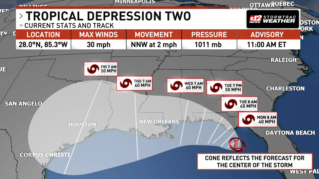
According to the National Hurricane Center, the system is currently moving through an environment that presents a complex tug-of-war between intensifying and weakening factors. While the depression has not yet reached the sustained wind threshold of 39 mph required for tropical storm designation, the forecast for intensification is aggressive. Forecasters expect the system to be upgraded to Tropical Storm Isaias by Tuesday night or Wednesday morning. If environmental conditions remain favorable, the system is projected to become the first hurricane of the 2026 Atlantic hurricane season by Thursday.
The Meteorological Battle: Warm Water vs. Wind Shear
The rapid intensification of Tropical Depression 9 into what could become Hurricane Isaias depends on a delicate balance of atmospheric and oceanic conditions. Meteorologists from The Weather Company have identified two primary competing drivers currently influencing the system’s development.
Favorable Intensification Drivers
Sea surface temperatures in the Gulf of Mexico are currently hovering in the 80s (°F). This provides a massive reservoir of thermal energy, which acts as the primary fuel for tropical cyclones. High water temperatures allow for increased evaporation and moisture content in the lower atmosphere, which can lead to the deep convection necessary for a system to strengthen into a hurricane.
Hostile Environmental Constraints
Counteracting this thermal energy is a significant amount of wind shear. A sagging jet stream, currently positioned far to the south, is creating hostile wind shear across the Gulf. Wind shear refers to the change in wind speed and direction at different altitudes in the atmosphere. For a tropical system to organize and intensify, it requires a vertically stacked structure. Excessive wind shear can “tilt” the storm or blow the convection away from the center of circulation, effectively preventing the system from strengthening.
If the system encounters lower wind shear as it moves northward, the potential for a Category 1 or Category 2 hurricane at landfall increases significantly. Conversely, if the shear remains high, the storm may struggle to maintain its organization as it approaches the coast.
Forecasted Track and Landfall Uncertainty
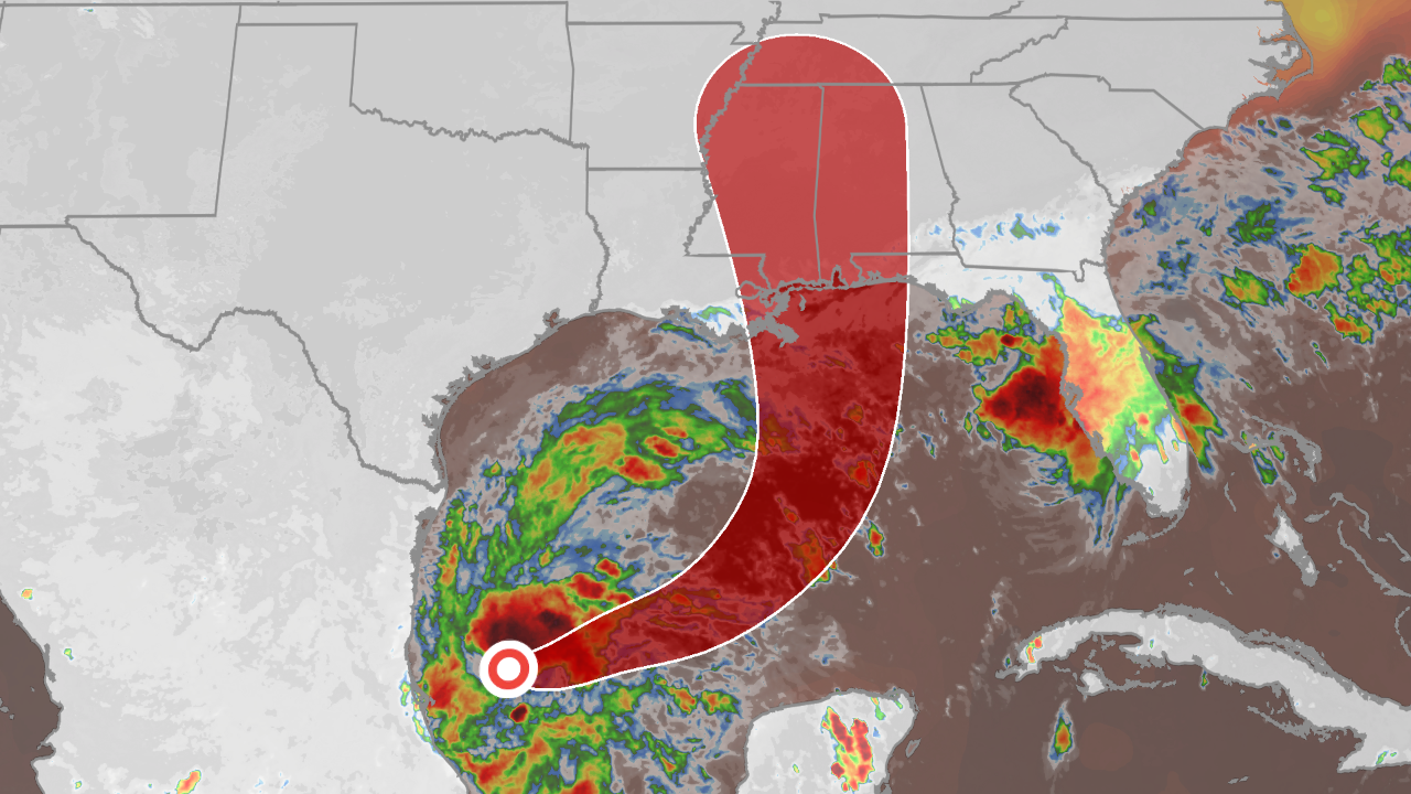
One of the most critical aspects of the current forecast is the uncertainty regarding the exact path and speed of the system. While most computer models agree that the storm will eventually move toward the northern Gulf Coast, the specific landfall location remains a subject of intense study.
Currently, the projected path suggests the system will initially drift east before being pulled northward by atmospheric steering currents. The potential landfall zone is broad, spanning from the coastlines of Louisiana to the Florida Panhandle. This window is expected to open between Friday, October 9, and Saturday, October 10, 2026.
Because the system is in an early stage of development, the “spaghetti plots” used by meteorologists show a wide spread of potential tracks. This variability means that even small changes in the strength of the jet stream could shift the heaviest rain and strongest winds by hundreds of miles.
Comparative Data: The 2026 Atlantic Hurricane Season
The 2026 season has been characterized by meteorologists as one of the quietest on record, largely due to the presence of El Niño conditions. El Niño typically increases vertical wind shear in the Atlantic basin, which tends to inhibit the formation and intensification of tropical cyclones. However, the emergence of Tropical Depression 9 serves as a reminder that significant storms can still develop late in the season.
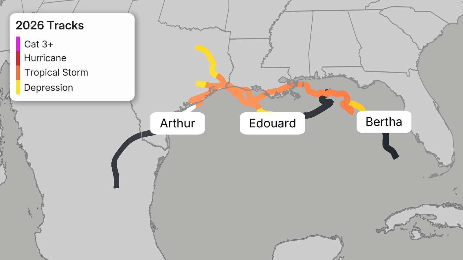
To understand the context of the current threat, it is helpful to look at the named storms that have already impacted the Gulf of Mexico this year:
| Storm Name | Date of Impact | Primary Impact and Statistics |
|---|---|---|
| Tropical Storm Arthur | June 2026 | Landfall in Texas; produced a record 37.53 inches of rain in Alexandria, LA |
| Tropical Storm Bertha | July 22, 2026 | Struck the Biloxi Wildlife Management Area in St. Bernard Parish; widespread 1–5 inches of rain |
| Tropical Storm Edouard | September 1, 2026 | Landfall with sustained winds of approximately 60 mph |
| Hurricane Isaias (Forecast) | Oct 9–10, 2026 | Potential Category 1 or 2 hurricane; forecasted 3–10 inches of rain |
Regional Impacts and Hazards
The threats posed by Tropical Depression 9 and its potential evolution into Hurricane Isaias vary significantly depending on geographic location. The primary hazards are categorized into coastal threats and inland threats.
Coastal Threats: Surge, Winds, and Rip Currents
For residents along the Gulf Coast, the most immediate concerns involve the interaction between the storm and the ocean. Even if the center of the storm stays well east of the Texas coast, the presence of a large system in the Gulf can generate significant maritime hazards.
The National Weather Service (NWS) office in Corpus Christi has already issued a coastal flood advisory for the barrier islands through Tuesday evening. Forecasters warn that water could be pushed up onto the beach dunes of the Aransas, Kleberg, Nueces, and Calhoun islands. Such flooding can lead to blocked roads and hazardous driving conditions. Additionally, even without a direct hit, the system is expected to generate dangerous rip currents along the Texas and Louisiana coasts.
If the system intensifies into a hurricane and makes landfall in the Louisiana or Florida Panhandle regions, the risk of a significant storm surge increases. Storm surge—the rise in sea level caused by a storm’s winds pushing water toward the shore—can cause devastating flooding in low-lying coastal communities.
Inland Threats: Heavy Rainfall and Flash Flooding
While wind is a major factor for coastal areas, rainfall remains the primary concern for those located further inland. As the system moves toward the northern Gulf Coast and eventually moves across the Southeast, heavy rain bands are expected to follow.
Most areas are expected to receive between 3 and 6 inches of rainfall, but localized totals could reach up to 10 inches. This volume of water poses a severe risk of flash flooding, particularly in areas where drainage systems may be overwhelmed. The threat of flooding is not limited to the Gulf Coast; the heavy rain is expected to push through the Appalachians, the Ohio Valley, and the Mid-Atlantic through the weekend of October 10–11.
Furthermore, the National Hurricane Center has noted that isolated tornadoes are possible near the coast both before and after the system makes landfall. Residents in these areas should be prepared for rapidly changing weather conditions.
What It Means for You
As the forecast for Tropical Depression 9 evolves, different groups of people should prepare for specific implications:
For Gulf Coast Residents (Louisiana to Florida)
If you reside in the projected landfall zone, you should treat this as a developing situation.
For Texas Coastal Residents
Even if the storm stays east of your location, do not ignore the advisories.
For Inland Residents (Southeast, Appalachians, Mid-Atlantic)
Counterpoints and Open Questions
Despite the high level of activity from meteorological agencies, several significant uncertainties remain. The most prominent question is the intensity of the storm at landfall. While the current trajectory points toward a hurricane, the “hostile” wind shear mentioned by The Weather Company remains a major wildcard. If the jet stream remains positioned as it is, the storm may struggle to maintain its core, potentially resulting in a much weaker landfall than currently anticipated.
There is also the question of the exact track. While models currently favor a path toward the Louisiana/Florida Panhandle, tropical systems are notoriously sensitive to atmospheric shifts. A slight change in the steering currents could move the center of the storm much closer to the Texas coast or push it further out into the open Gulf.
Finally, while the 2026 season has been quiet due to El Niño, the late-season intensification of this system challenges the assumption that the season is winding down. This raises questions for long-term seasonal forecasting: will the remaining months of 2026 remain quiet, or is the atmosphere entering a more active phase?
What Happens Next
Several key milestones will determine the severity of this weather event over the coming days:
Frequently Asked Questions
Will Hurricane Isaias hit Texas directly?
Most current computer forecast models agree that the center of Tropical Depression 9 (and the potential Hurricane Isaias) will stay east of the Texas coast. However, Texas is not entirely unaffected. The National Weather Service has already issued coastal flood advisories for parts of the Texas coast, and residents should expect rip currents, gusty winds, and enhanced rainfall chances through the weekend.
When will the storm make landfall?
Forecasters are currently looking at a landfall window between Friday, October 10, and Saturday, October 11, 2026. The exact location is expected to be somewhere between Louisiana and the Florida Panhandle. Because the storm is still in its formative stages, this timing and location could shift as more data is collected by hurricane hunter aircraft.
How much rain should I expect?
Rainfall amounts will vary greatly by location. Most areas impacted by the system are expected to see between 3 and 6 inches of rain. However, in localized areas, particularly where heavy rain bands stall, totals could reach up to 10 inches. Inland areas, including the Appalachians and the Mid-Atlantic, should prepare for significant rainfall that could trigger flash flooding.
What is the difference between a tropical storm watch and a warning?
According to official definitions used by the National Hurricane Center, a tropical storm watch means that tropical storm conditions are possible within the watch area, generally within a 48-hour window. A tropical storm warning means that those conditions are expected within the warning area, generally within a 36-hour window. A warning indicates a much higher level of certainty and a shorter timeframe for preparation.
As Tropical Depression 9 continues to organize in the warm waters of the Gulf, the focus remains on the potential for rapid intensification and the wide geographic area that could be impacted by its rainfall and storm surge. Residents from the Gulf Coast to the Mid-Atlantic are advised to remain vigilant and monitor official updates from the National Hurricane Center and local weather authorities.
References
Featured image: Image via WPEC