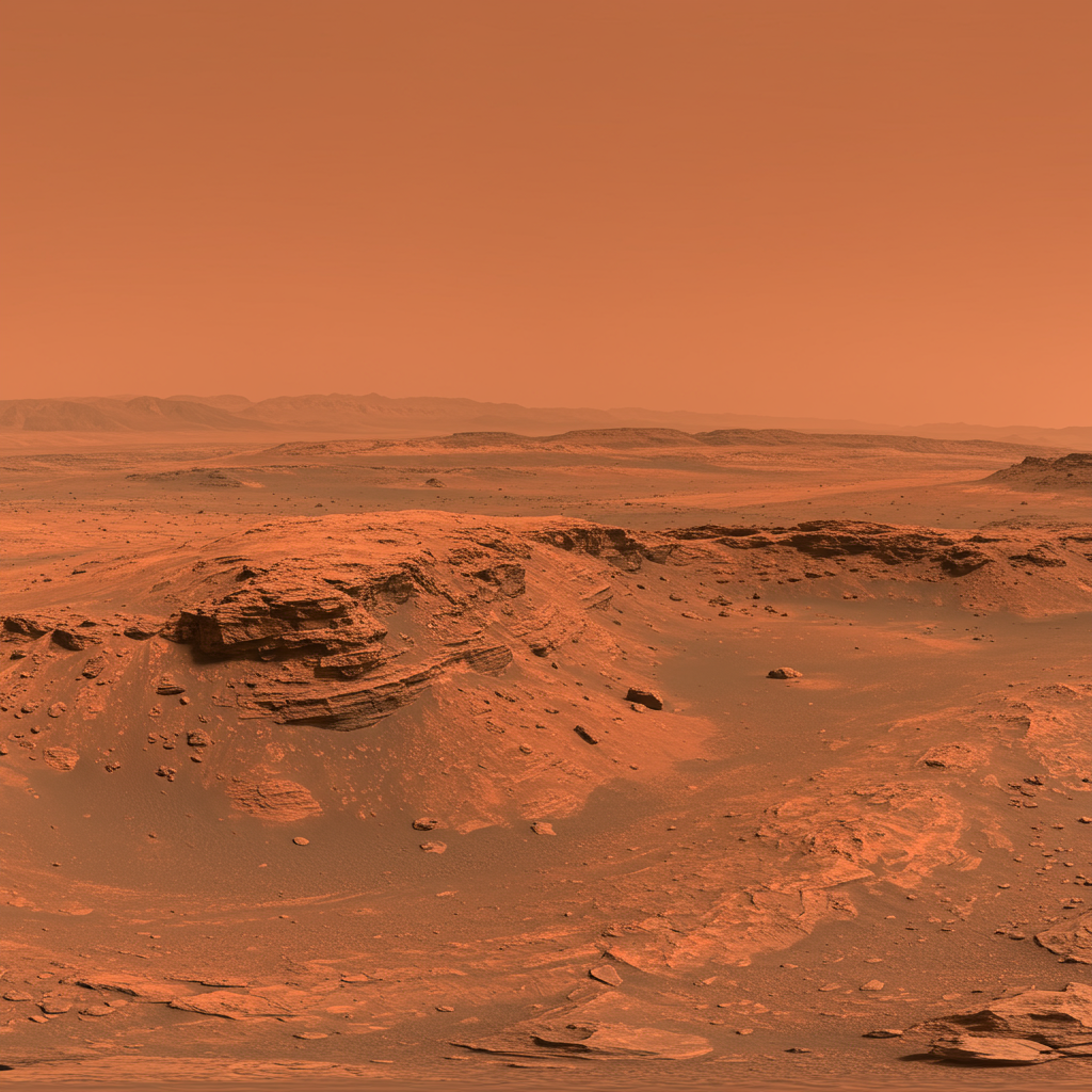
NASA’s Perseverance rover recently delivered breathtaking insights into the Martian landscape, capturing a remarkable 360-degree panorama of an area christened “Falbreen” within Jezero Crater. This expansive vista, taken on May 26, 2025 – the 1,516th Martian day, or sol, of its mission – reveals a remarkably clear sky and provides compelling evidence of the Red Planet’s complex geological history. Stitched together from 96 individual images by the rover’s Mastcam-Z camera, this detailed mosaic offers a compelling glimpse into Mars as we continue humanity’s ambitious journey of discovery.
Unveiling Falbreen’s Martian Majesty: A Panoramic Perspective
The Falbreen panorama stands out not only for its sheer scope but also for its exceptional clarity. Through enhanced-color processing, designed to boost visual contrast and highlight subtle variations, the Martian sky appears a “deceptively blue” hue. While stunning, this visual effect accentuates terrain and atmospheric differences, reminding us that Mars’ true atmospheric color is predominantly reddish due to suspended dust. The pristine conditions on the day of capture, notably free of significant dust, allowed the Mastcam-Z imager to resolve distant hills up to 65 kilometers (40 miles) away, showcasing unparalleled visibility.
This meticulous imaging effort provides more than just pretty pictures; it serves as a critical tool for scientific investigation. The panorama allows scientists to analyze geological formations, track the rover’s movements, and identify potential targets for sample collection. It’s a testament to the ingenuity behind the Mars 2020 mission, demonstrating how comprehensive visual data drives our understanding of planetary evolution.
A Geologist’s Dream: Key Discoveries Within the Vista
The Falbreen panorama is rich with features that provide vital clues about Mars’ past and present. Each element tells a story, contributing to a larger narrative of Martian geology and the ongoing search for ancient life.
The 43rd Abrasion Patch: Prominently featured, just left of center and near the bottom, is a bright white circular patch. This mark, approximately 5 centimeters (2 inches) wide, signifies the 43rd rock that Perseverance has abraded since its landing in February 2021. This procedure, performed on May 22nd, involves grinding away the rock’s surface layer to expose pristine material beneath, untouched by the harsh Martian environment. Such abrasions are crucial for scientists to analyze the composition of subsurface rocks, paving the way for targeted core sample collection.
The “Float Rock” Enigma: An intriguing black “float rock” captures attention, appearing precariously balanced on a sand ripple. This rock, located about 14 feet (4.4 meters) from the rover, is more likely sitting directly on the underlying rocky surface, with Martian dust having gradually accumulated around its base over time to form the ripple. Geologists infer that this float rock was transported to its current position by natural processes like wind, water, or erosion, before the surrounding sand ripple formed. Studying such erratics provides insights into historical geological events and material transport mechanisms.
Perseverance’s Footsteps: Towards the right edge of the mosaic, the distinct tracks of the Perseverance rover are clearly visible. These tracks extend for approximately 300 feet (90 meters) before veering left, leading towards a previously investigated geological stop nicknamed “Kenmore.” These tracks are not just a record of movement; they offer data on terrain interaction and help map the rover’s journey through Jezero Crater.
Ancient Geological Boundaries: The panorama also reveals a clear “contact” line, or boundary, across the mid-distance between two distinct geological units. This transition shifts from lighter-toned, near-field rocks rich in olivine – a common mineral in Earth’s upper mantle – to darker-toned rocks further away, which are thought to be much older and contain clay minerals. Scientists believe the Falbreen site itself might predate Jezero Crater, making it potentially the oldest terrain the Perseverance rover has explored to date. This distinction is vital for understanding the crater’s formation and its potential for preserving signs of ancient life.
The Technological Prowess Behind Martian Discovery
Capturing such detailed images requires sophisticated instrumentation and immense collaborative effort. The Mastcam-Z camera, central to this panorama, is more than just a camera; it’s a high-resolution imaging system equipped with zoom capabilities. This instrument allows for various viewing modes:
Figure A: Natural Color: Provides a standard representation of the Martian landscape.
Figure B: 3D Anaglyph: Composed of 192 separate images, this version is designed for 3D viewing with red-blue glasses, offering a sense of depth crucial for geological analysis.
- Figure C: Annotated Version: This enhanced mosaic includes indicators showing the distances (in kilometers) of faraway hills, further emphasizing the exceptional visibility during the capture.
- www.jpl.nasa.gov
- www.universetoday.com
- www.jpl.nasa.gov
- www.jpl.nasa.gov
- www.jpl.nasa.gov
The development and operation of the Mastcam-Z instrument are a testament to global scientific partnership. Arizona State University leads the operations, collaborating with Malin Space Science Systems in San Diego on the camera’s design, fabrication, testing, and operation. Further collaboration with the Niels Bohr Institute of the University of Copenhagen focuses on the design, fabrication, and testing of calibration targets, ensuring the accuracy of the data. NASA’s Jet Propulsion Laboratory (JPL), managed by Caltech, is responsible for building and managing the operations of the Perseverance rover itself, demonstrating a multi-faceted approach to complex space missions.
Perseverance’s Broader Vision: Paving the Way for Humanity
The work of the Perseverance rover, exemplified by the Falbreen panorama, is a cornerstone of NASA’s long-term Mars Exploration Program. Its primary mission goes beyond just capturing stunning images; it’s intrinsically linked to the ambitious Mars Sample Return campaign, a multi-stage initiative aimed at bringing Martian samples back to Earth for unparalleled scientific study.
Perseverance is equipped with a unique subsystem designed to collect and securely store Martian rock and sediment samples. It uses a coring drill on its robotic arm and then seals these samples in titanium tubes within its chassis. These precious samples are later deposited in designated “depots” on the Martian surface, awaiting future NASA and European Space Agency (ESA) missions that will retrieve them and transport them to Earth. This is crucial because Earth-based laboratories possess instruments far too large and complex to send to Mars, offering a level of analysis currently impossible on the Red Planet.
Beyond sample collection, a core objective of the Perseverance rover is astrobiology – the search for signs of ancient microbial life. Jezero Crater was specifically chosen for its potential to have harbored microbial life in its ancient past, making it a prime target for probing Martian rocks for evidence of past biological activity.
The rover also hosts a suite of advanced instruments like PIXL, SHERLOC, MOXIE, MEDA, and RIMFAX, each contributing unique data. Its enhanced sky crane landing system, a significant technological advancement, allows it to safely land in more challenging terrains, opening up even more scientifically compelling exploration areas.
Expanding Our Understanding: Dust Devils and Human Endeavors
While the Falbreen panorama showcases a calm day, the Perseverance rover also contributes to our understanding of Mars’ dynamic atmosphere. It has captured unprecedented images and even groundbreaking audio recordings of dust devils swirling across Jezero Crater. These atmospheric phenomena, some as wide as 210 feet (65 meters), offer crucial insights into Martian wind patterns, surface-atmosphere interactions, and how dust-lifting processes impact the planet’s climate over time. The ability to hear the dust devils, a first for Mars, adds a new dimension to atmospheric science. Every new data point from these events refines existing climate models of Mars, leading to more accurate predictions and a deeper comprehension of the planet’s environment.
Ultimately, these stunning views and scientific breakthroughs are more than just data points; they are a prelude to humanity’s future in space. As Sean Duffy, acting NASA administrator, commented, such vistas directly link to NASA’s broader ambitions for human space exploration, emphasizing that groundbreaking missions like Perseverance are propelling humanity’s journey toward sending astronauts to the Martian surface.
Frequently Asked Questions
What unique geological features did the Perseverance rover capture in the Falbreen panorama?
The Falbreen panorama, captured by the Perseverance rover, unveiled several significant geological features. It prominently displayed the 43rd rock abrasion patch, a bright white circular mark where the rover drilled to analyze subsurface material. Also visible was a “float rock,” a black rock appearing to rest on a sand ripple, providing clues about its origin and how Martian dust accumulates. The panorama further showed the rover’s own tracks leading to a previous geological stop called “Kenmore,” and a distinct boundary line between lighter-toned, olivine-rich rocks and older, darker, clay-bearing rock units, suggesting Falbreen might be the oldest terrain explored by the rover so far.
How does NASA use images like the Falbreen panorama to advance the Mars Sample Return mission?
Images like the Falbreen panorama are crucial for advancing the Mars Sample Return mission. They provide detailed visual context for the rover’s discoveries, allowing scientists on Earth to identify promising rock and soil targets for sample collection. By analyzing the features, geological context, and mineralogical clues captured in these high-resolution images, the science team can precisely determine where to perform abrasions and drill core samples. These carefully selected and sealed samples will then be stored for future retrieval by subsequent missions, ultimately to be brought back to Earth for in-depth analysis using advanced laboratory equipment.
Why is the “deceptively blue” Martian sky observed by Perseverance significant for scientists?
The “deceptively blue” sky observed in the Falbreen panorama, captured by Perseverance, is significant for atmospheric scientists because it highlights periods of exceptional atmospheric clarity on Mars. While the Martian atmosphere is typically reddish due to suspended dust, the blue appearance, achieved through enhanced-color processing, indicates very low dust levels at the time of imaging. This provides valuable data on atmospheric conditions, dust transport, and the overall climate dynamics of the Red Planet. Understanding these variations helps refine Martian climate models and provides insights into how the thin Martian atmosphere interacts with the surface over time.
The Continuing Journey on Mars
The Falbreen panorama is just one snapshot in the ongoing saga of the Perseverance rover. Each image, every sample collected, and every scientific observation pushes the boundaries of our knowledge about Mars. As Perseverance continues its exploration of Jezero Crater, searching for signs of ancient life and caching samples for future return, it reinforces humanity’s relentless curiosity and our unwavering commitment to unraveling the mysteries of the universe. The data gathered from missions like Perseverance not only deepen our scientific understanding but also inspire the next generation of explorers, propelling us closer to the day humans set foot on the Red Planet.


