The Texas Hill Country, celebrated for its stunning granite and limestone landscapes carved by ancient waterways, recently became the scene of a devastating natural disaster. A catastrophic flash flood event transformed picturesque streams and rivers into raging torrents, causing widespread destruction and tragic loss of life, particularly impacting children’s summer camps situated in areas known to be highly susceptible to flooding.
This region’s unique geography, characterized by steep hills and rocky terrain, acts as a natural funnel. When intense rainfall occurs, the hard, dry soils and rock surfaces absorb very little water. Instead, gravity pulls the excess rain rapidly downhill, channeling it into creeks and rivers with extreme speed and force. This inherent characteristic has earned the area the grim moniker “Flash Flood Alley,” a designation experts use due to its documented history of sudden, dangerous inundations. Geological factors, like the Guadalupe Riverbed’s limestone composition, further exacerbate the danger, causing water to behave almost like it’s flowing over concrete, accelerating its speed and destructive power.
An Unprecedented Downpour Strikes
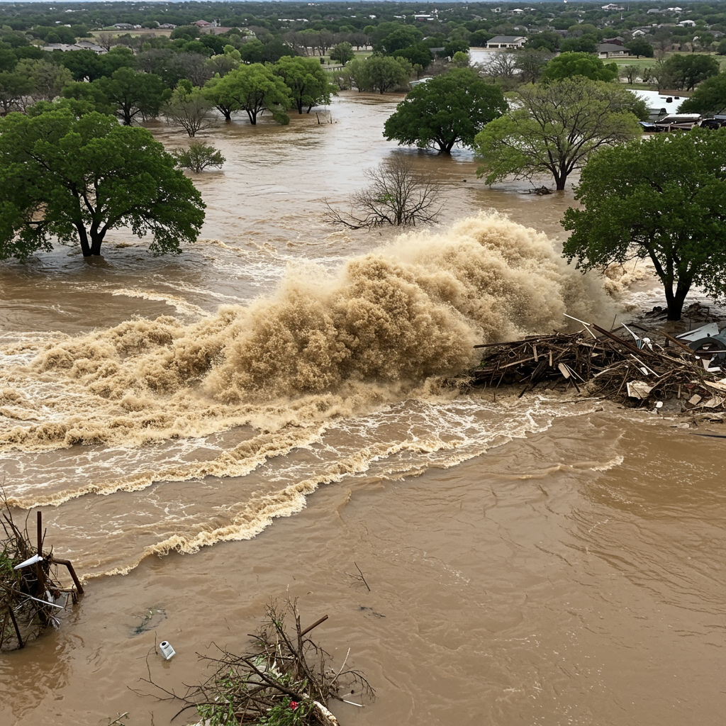
Early on the Fourth of July weekend, Central Texas and parts of Kerr County were hit by rainfall far exceeding initial forecasts. While predictions suggested relatively minor amounts, some areas experienced a staggering 10 to 15 inches, with isolated spots receiving over 20 inches in just a few hours. This deluge, fueled by warm, moist air from the Gulf of Mexico and remnants of Tropical Storm Barry, created a slow-moving system that lingered over the vulnerable terrain.
The result was an exceptionally rapid and violent rise in water levels. The Guadalupe River, a central artery of the Hill Country, surged dramatically. At one point, state officials reported the river rose an astonishing 26 feet in just 45 minutes. Other accounts described a branch of the river jumping from approximately 7 feet to 29 feet in a matter of minutes between 4 a.m. and 6 a.m. on Friday morning. This sudden, immense volume of water, estimated to be around 100 billion gallons – nearly double the daily flow of Niagara Falls – overwhelmed dry riverbeds and spilled over banks with terrifying speed and power. While a historic flood in 1987 saw the Guadalupe River crest even higher, the recent event’s impact was compounded by a significantly higher population density in the area today.
Summer Camps Caught in High-Risk Zones
Several children’s camps located along the Guadalupe River and its tributaries sustained significant damage during the flood. Notably, many of these camps were situated within or bordered areas the federal government, specifically the Federal Emergency Management Agency (FEMA), designates as high-risk flood zones. FEMA maintains databases and maps identifying regulatory floodways – the most dangerous areas that will flood first – and areas with a 1% (1-in-100 year event) or 0.2% (1-in-500 year event) annual chance of flooding.
Camp Mystic, a nondenominational Christian summer camp for girls in western Kerr County, was particularly affected. Located at a dangerous confluence of the South Fork Guadalupe River and Cypress Creek, where floodwaters converged with immense force, both of Camp Mystic’s sites overlap with either the designated floodway or areas with a 1% or 0.2% annual flood chance. The camp was described as “horrendously ravaged,” with cabins destroyed and structures caked in mud. Ten minutes north on the South Fork is Camp La Junta, a boys camp. Parts of Camp La Junta’s property also lie within known flood zones, though some buildings are in lower-risk areas or entirely outside flood zones.
The Devastating Human Cost
The flash flooding resulted in a tragic loss of life. As of reports shortly after the event, the death toll had risen significantly across several central Texas counties. Kerr County was hardest hit, reporting a high number of fatalities, including children. Other counties reporting deaths included Travis, Burnet, Kendall, Williamson, and Tom Green.
A critical focus of the search and rescue efforts centered on finding missing individuals, especially those associated with Camp Mystic. Reports indicated 10 children and one counselor from the camp were initially missing. While many bodies found were pending identification, authorities continued searching for an unknown number of missing people, including campers, individuals in RVs, and others staying in rental properties along the river for the holiday weekend. The suddenness of the flood, striking in the middle of the night while most people were asleep, significantly contributed to the high number of casualties. Heartbreakingly, specific young Camp Mystic attendees were identified among the deceased, including 8-year-old Sarah Marsh and 9-year-old Janie Hunt, as well as twin 8-year-old granddaughters of a former newspaper publisher.
Search and rescue operations were extensive, involving hundreds of local, state, and federal responders, utilizing helicopters, boats, drones, and K9 units. Over 850 people were rescued in the initial hours, with more than 200 rescues conducted by various teams. The Texas Military Department alone reported conducting over 525 rescues or evacuations by air and ground shortly after the disaster. Officials vowed to continue searching until everyone was accounted for.
Questions About Warnings and Preparedness
The rapid and deadly nature of the flood raised critical questions regarding the timing and effectiveness of warning systems and preparedness measures, particularly why summer camps in known high-risk areas were not evacuated sooner.
While emergency management officials acknowledged the difficulty in precisely predicting the sheer magnitude of the rainfall that occurred, stating that forecasts did not fully anticipate the amount of rain that fell, state emergency response resources had been activated days prior due to increased flood threats. Swift water rescue teams and equipment were pre-positioned in the region and were immediately deployed as calls came in.
A timeline of warnings shows the National Weather Service (NWS) progression from issuing a flood watch to a flood warning and eventually an “exceedingly rare” flash flood emergency in the early hours of Friday. However, some local authorities’ first public warnings on social media appeared after the NWS had already declared a “very dangerous flash flooding event is ongoing.” State officials noted that local judges and mayors were personally contacted about potential flooding the day before, but under the law, evacuation decisions rest with local counties and mayors. This highlights the complex challenge local officials face in deciding whether to evacuate or advise sheltering in place, especially in the unique terrain of the Hill Country with its numerous low water crossings. Some accounts also suggest that river alarms installed after the 1987 flood may not be present everywhere along the river.
Voices from the Floodwaters
Personal accounts underscored the terrifying experience. Wyndham Etheridge, a 14-year-old camper at Camp La Junta, described waking up to people from across the camp seeking refuge in his cabin. As the water rose, they were forced to climb into the loft, but even that felt unsafe. Eventually, they were rescued, but the trauma lingered. Wyndham’s mother noted that all the boys at Camp La Junta were “pretty traumatized.” While Camp La Junta successfully accounted for everyone safely, the experience highlighted the extreme danger the flood presented even to those who ultimately survived.
Facing Future Risks: Climate Change and Adaptation
The catastrophic flood was described as a 1-in-100 year event, statistically having only about a 1% chance of occurring in any given year. However, extreme flooding events appear to be happening more frequently. Experts point to climate change as a contributing factor, as a warming atmosphere can hold more moisture, potentially leading to more intense rainfall events. Adding to the risk, Central Texas had been experiencing significant drought conditions before the flood, leaving the ground bone-dry and unable to absorb water, thus exacerbating rapid runoff.
Government response included state disaster declarations for affected counties and a major federal disaster declaration signed by the President, unlocking funding for assistance like temporary housing and repairs. While the immediate focus remained on search and rescue, the event prompts crucial discussions about land use planning in flood-prone areas, the effectiveness of warning systems, and the need for updated infrastructure and preparedness strategies in the face of increasingly unpredictable extreme weather.
Frequently Asked Questions
What makes the Texas Hill Country particularly prone to flash floods?
The Texas Hill Country’s rugged geography, featuring steep hills and rocky terrain carved by waterways, significantly increases its flood risk. This landscape hinders water absorption during heavy rain, leading to rapid runoff that channels quickly into creeks and rivers. The area is often called “Flash Flood Alley” due to this characteristic. The limestone composition of riverbeds, like the Guadalupe, also speeds up water flow dramatically.
What summer camps were affected by the recent deadly Texas flood?
Camp Mystic, an all-girls Christian camp in western Kerr County, was severely impacted. It is located in a high-risk flood zone at the confluence of waterways and sustained extensive damage. Camp La Junta, a boys camp nearby, also had property within flood-prone areas, though its campers were successfully accounted for. Many camps along the Guadalupe River and its tributaries experienced damage.
What was the timing and effectiveness of flood warnings before the event?
Official warnings from the National Weather Service escalated from a flood watch to a flash flood emergency in the hours before the peak flooding. State emergency resources were pre-positioned days prior. However, the sheer magnitude of the rainfall exceeded predictions, and the flood occurred suddenly in the middle of the night. Questions remain about whether the timing and dissemination of local warnings were sufficient to enable evacuation from the high-risk areas in time.
Conclusion
The deadly flash flood in the Texas Hill Country served as a stark and tragic reminder of nature’s power and the inherent risks faced by communities and facilities located in historically flood-prone areas like “Flash Flood Alley.” The event resulted in significant casualties, including campers and staff from children’s summer camps situated in known flood zones, and necessitated massive search and rescue operations. While emergency responders displayed incredible courage and effort, the disaster highlights ongoing challenges in predicting extreme rainfall, effectively warning populations, and ensuring adequate preparedness, especially for vulnerable groups like children at summer camps. As the region recovers and rebuilds, the focus must turn to evaluating warning systems, land use policies, and infrastructure to better protect lives against the growing threat of increasingly intense weather events. Staying vigilant and understanding local flood risks remain paramount for anyone living in or visiting such areas.
Word Count Check: 1197