Beneath Antarctica’s vast, frozen expanse, a revolutionary new map has unveiled an unseen world of mountains, valleys, and deep channels. This groundbreaking discovery offers an unprecedented view of the continent’s subglacial landscape, promising to transform our understanding of Earth’s climate future and the critical role the frozen continent plays in global sea-level rise. For decades, much of what lay beneath Antarctica’s formidable ice sheet remained a profound mystery, with scientists knowing more about the surfaces of distant planets than our own icy continent’s foundation.
This cutting-edge research, published in the esteemed journal Science, combines sophisticated satellite observations with the fundamental physics of ice flow. The result is the most detailed and comprehensive map ever created of Antarctica’s hidden landscape. This innovative approach provides scientists with crucial data, allowing them to better predict how the immense Antarctic ice sheet will respond to ongoing global warming.
Unmasking Antarctica’s Hidden World: A Scientific Breakthrough
For generations, the true contours of the land beneath Antarctica’s miles-thick ice sheet have been largely a riddle. Traditional methods, like ground-based or airborne radar surveys, could only “see” in narrow lines, often tens of kilometers apart. Imagine trying to map the intricate peaks and valleys of the Scottish Highlands or the European Alps if they were buried under ice, and you could only take occasional, widely spaced aerial photographs. Vast areas remained unmapped, leaving researchers to make educated guesses about the crucial bedrock topography that shapes the ice above. This limited understanding meant significant features, like bedrock valleys steering massive ice flows, could be easily missed.
However, a team led by Dr. Helen Ockenden from the University of Grenoble-Alpes and Prof. Robert Bingham of the University of Edinburgh developed a novel technique called Ice Flow Perturbation Analysis (IFPA). This method leverages the subtle ways that underlying geological features impact the movement and surface patterns of the ice above. Dr. Ockenden likened it to how eddies on a river’s surface can reveal submerged rocks. When glaciers flow over a ridge or a valley in the bedrock, these features manifest in discernible patterns on the ice surface and in the ice’s velocity. By combining high-resolution satellite data of the ice surface with physics-based models of ice dynamics, the researchers could effectively reconstruct the landscape hidden beneath.
Revolutionary Discoveries Beneath the Ice Sheet
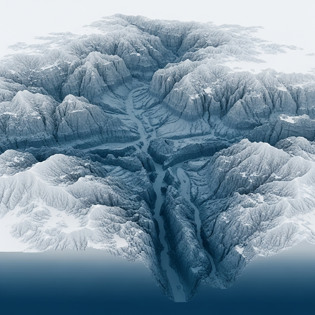
The new map provides an “enormous level of detail,” far surpassing previous efforts. It has revealed tens of thousands of previously unknown hills and ridges that were entirely missed by older, less comprehensive surveys. Furthermore, existing knowledge of Antarctica’s buried mountain ranges and canyons has been dramatically enhanced, now captured with unprecedented clarity.
Among the most intriguing finds is a massive, deep channel incised within the Maud Subglacial Basin. This significant feature is, on average, 50 meters deep, 6 kilometers wide, and stretches for nearly 400 kilometers – a distance roughly equivalent to driving from London to Newcastle. Scientists believe some of these ancient structures, including deeply carved ice rivers and U-shaped valleys, may even predate the formation of the current Antarctic ice sheet, which began to take shape around 14 million years ago. Dr. Ockenden noted the excitement of seeing these “new landscapes,” comparing it to encountering the topography of Mars for the first time. The map also resolved features ranging in size from approximately 1.2 miles to 18.6 miles, showcasing remarkable precision.
The Critical Link: Ice Flow, Climate Change, and Sea-Level Rise
The detailed understanding of Antarctica’s hidden landscape is not merely an academic curiosity; it is a critical tool in the fight against climate change. The underlying bedrock topography fundamentally dictates how quickly glaciers move and how rapidly they can retreat in a warming climate. For example, a submerged ridge can slow down a glacier, while a deep channel can accelerate its flow, making it more vulnerable to melting.
Previous computer models, essential for predicting future melt rates and global sea-level rise, were limited by the sparse data on this subglacial terrain. With a clearer picture of all the ridges, hills, mountains, and channels, scientists can now develop far more accurate models of how Antarctica might change in the future. As Dr. Peter Fretwell, a senior scientist at the British Antarctic Survey, affirmed, this map is a “really useful product” that fills crucial gaps, offering a better picture of future ice melt and its contribution to global sea levels. The future speed of melting in Antarctica is widely regarded as one of the biggest unknowns in climate science, making this research profoundly impactful.
Charting the Course for Future Antarctic Exploration
While this new map represents a monumental leap forward, the researchers acknowledge that it relies on assumptions about complex ice flow dynamics. Therefore, it serves as a vital guide for future, more targeted geophysical surveys. This pioneering work indicates precisely where additional, higher-resolution studies – using technologies like radar swath imaging, magnetotellurics, and seismic surveys – should be focused to capture even finer details.
Understanding these minute details is paramount for refining ice flow models further. The scientific community sees this map as a strategic tool, laying the groundwork for integrated observation and modeling approaches, especially in anticipation of future international collaborations like the International Polar Year 2031-2033. This ongoing exploration of Antarctica’s buried world will continue to shape our understanding of the frozen continent’s geological history and its profound influence on global climate systems.
Frequently Asked Questions
What makes this new map of Antarctica’s hidden landscape so unique?
This map is unique because it combines high-resolution satellite data of the ice surface with advanced physics-based models of ice flow (Ice Flow Perturbation Analysis or IFPA). Unlike traditional radar surveys, which provide sparse, linear data, this innovative method allows scientists to infer the full, detailed bedrock topography beneath miles of ice. It reveals tens of thousands of previously unknown features and offers unprecedented clarity on existing mountain ranges, valleys, and even deep channels like the 400 km long one in the Maud Subglacial Basin.
How does understanding Antarctica’s subglacial topography help predict sea-level rise?
The subglacial landscape directly influences how glaciers move and melt. Underlying mountains, ridges, and valleys act like controls, either slowing down or accelerating the flow of ice towards the ocean. By precisely mapping these features, scientists can create more accurate computer models of glacier dynamics. These enhanced models provide better predictions of how rapidly the Antarctic ice sheet will contribute to global sea-level rise in a warming climate, offering crucial insights for future climate projections and mitigation strategies.
What are the next steps for scientists after this groundbreaking mapping of Antarctica’s buried world?
This map serves as a crucial guide for future targeted research. Scientists will use it to plan more focused geophysical surveys, employing advanced techniques such as radar swath imaging, magnetotellurics, and seismic surveys. These detailed observations will help validate and refine the current findings, addressing any uncertainties and capturing even finer-scale geological features. The goal is to continuously improve ice flow dynamics models and foster international collaboration, such as during the upcoming International Polar Year, to gain an even deeper understanding of Antarctica’s hidden landscape and its climate implications.
Conclusion
The unveiling of Antarctica’s incredibly detailed subglacial landscape marks a pivotal moment in polar research and climate science. This revolutionary map not only satisfies our inherent curiosity about Earth’s hidden geographies but, more importantly, provides an indispensable tool for understanding the profound impacts of climate change. By bridging the knowledge gap between the ice’s surface and the bedrock beneath, scientists are now better equipped to forecast the future of global sea-level rise with greater accuracy. This unprecedented insight into Antarctica’s buried world will undoubtedly propel new discoveries, guiding future exploration and refining our collective efforts to comprehend and adapt to a changing planet.