The Atlantic hurricane season has officially ignited with Hurricane Erin, a monumental Category 5 storm that rapidly intensified over the weekend. This powerful system now poses an urgent threat to the Caribbean. Forecasters warn of severe conditions, including widespread flooding and dangerous landslides. Residents across the Leeward Islands, U.S. Virgin Islands, and Puerto Rico must remain vigilant. This article details Erin’s astonishing strength, its projected path, and the critical impacts to expect.
Erin’s Unprecedented Intensification and Power
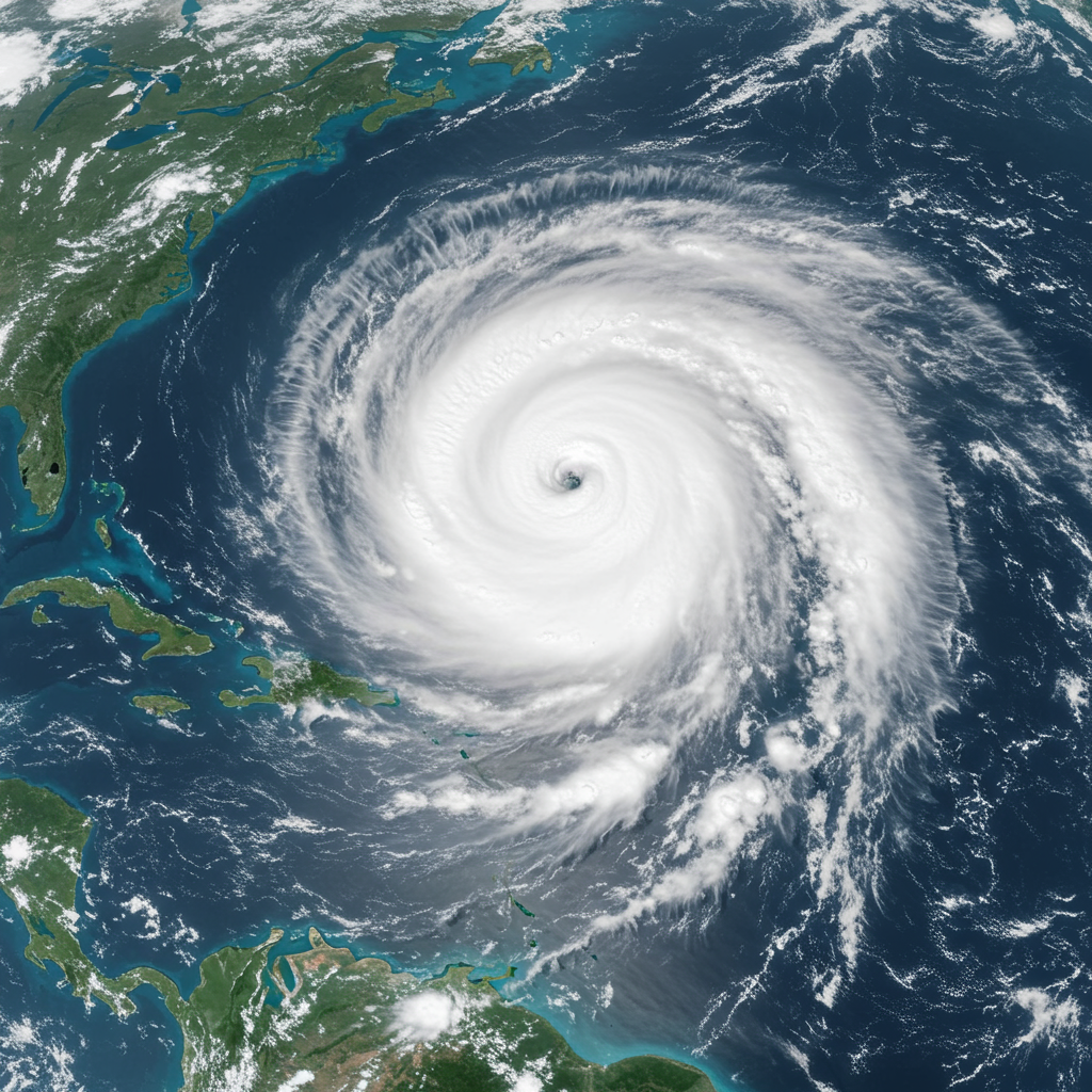
Hurricane Erin has astonished meteorologists with its swift escalation. On Saturday, August 16, 2025, it transformed from a tropical storm into a Category 5 storm within just 24 hours. Its maximum sustained winds soared to an alarming 160 miles per hour. This rapid intensification highlights a concerning trend. Scientists link such rapid strengthening to warming ocean temperatures. Warmer waters provide more fuel for hurricanes. The atmosphere also holds more water vapor. This allows storms to unleash more rain and intensify quickly.
Erin is the first hurricane of the 2025 Atlantic season. It is also the fifth named storm. The National Hurricane Center (NHC) described it as “very powerful.” This extreme growth presents significant challenges for forecasting. It also complicates emergency response planning.
Immediate Threat to Caribbean Nations
As of Saturday, Erin was moving west at about 16 to 17 miles per hour. It is currently located north of Anguilla. The NHC predicts a turn toward the west-northwest. Its center is likely to pass just north of the northern Leeward Islands, the U.S. Virgin Islands, and Puerto Rico through Sunday.
These islands face significant immediate risks. Tropical storm watches are active for St. Martin, St. Barthelemy, and Sint Maarten. Heavy rainfall is a primary concern. Some areas could see up to 6 inches of rain. This much rain can cause considerable flash flooding. The risk of landslides and mudslides is also high. The U.S. government has deployed over 200 FEMA employees to Puerto Rico. They are preparing for potential impacts. Puerto Rico’s Housing Secretary confirmed 367 shelters are ready. The U.S. Coast Guard has closed several seaports in the region.
Beyond the Direct Path: Wider Coastal Impacts
While Erin’s direct center is expected to largely remain at sea, its immense size generates far-reaching effects. Its hurricane-force winds extend about 30 miles from the center. Tropical-storm-force winds reach up to 140 miles. This massive system will produce dangerous conditions across a wide area.
Life-threatening surf and rip currents are forecast along the U.S. East Coast. This includes areas like North Carolina’s Outer Banks, Long Island, New York, and Cape Cod, Massachusetts. These conditions could begin as early as Monday, August 18, and persist into next week. Boaters in coastal North Carolina, particularly around Frying Pan Shoals and river mouths, face hazardous conditions. Coastal flooding and beach erosion are also likely.
The Turks and Caicos Islands, Bahamas, and Bermuda also face indirect impacts. These include strong winds and high surf. Officials in the Bahamas are preparing public shelters. They urge residents to closely monitor the storm’s volatile nature.
Hurricane Erin’s Projected Longevity and Season Context
The NHC expects Erin’s intensity to fluctuate over the weekend. However, it will likely remain a major hurricane through the middle of next week. A major hurricane is classified as Category 3 or higher.
This intense storm arrives in a projected unusually busy 2025 Atlantic hurricane season. Forecasters initially predicted up to 18 named storms this year. They also anticipated up to nine hurricanes and five major hurricanes. Erin is the first hurricane of the season. Previous named tropical storms include Andrea, Barry, Chantal, and Dexter. Barry caused severe flooding and over 130 deaths in Mexico and Central Texas. Chantal led to significant flooding and two fatalities in North Carolina.
Preparing for Storm Impacts
Effective hurricane preparedness is crucial. This is true even when a storm’s direct path avoids your location. Always have an emergency plan. Keep essential supplies readily available. Stay informed through official weather sources like the National Hurricane Center.
Rip currents pose a significant danger. They are the leading cause of weather-related deaths in the Carolinas. If caught in a rip current, remember to stay calm. Do not swim against the current. Instead, swim parallel to the shoreline. Once out of the current, swim at an angle back to the beach. Look for signs of rip currents: choppy water, breaks in wave patterns, or lines of debris moving seaward. Local areas, like Wilmington, North Carolina, are particularly vulnerable to flooding. This is due to recent heavy rainfall. Residents should prepare for standing water.
Frequently Asked Questions
What makes Hurricane Erin’s rapid intensification so unusual?
Hurricane Erin’s rapid shift from a tropical storm to a Category 5 hurricane in just 24 hours is highly unusual. This rapid intensification is fueled by abnormally warm ocean waters and abundant atmospheric moisture. Scientists increasingly link this phenomenon to climate change. Such rapid strengthening challenges meteorologists. It makes forecasting future intensity difficult. It also gives communities less time to prepare for sudden, extreme impacts.
Which Caribbean islands are directly impacted by Hurricane Erin’s immediate threat?
The center of Hurricane Erin is forecast to pass just north of the northern Leeward Islands, the U.S. Virgin Islands, and Puerto Rico. These regions are under direct threat from heavy rainfall. This rain could lead to flash flooding, landslides, and mudslides. Additionally, tropical storm watches are in effect for St. Martin, St. Barthelemy, and Sint Maarten. These islands could experience tropical storm conditions within 12 hours.
What safety measures should residents and coastal visitors take due to Hurricane Erin?
All residents and visitors in affected regions should monitor official weather updates closely. Prepare an emergency kit with food, water, and essential supplies. If you are in a low-lying or flood-prone area, be ready to evacuate. Pay attention to rip current warnings, even far from the storm’s center. Never swim against a rip current; instead, swim parallel to the shore. Coastal residents should also prepare for potential beach erosion and coastal flooding, especially around high tide.
Staying Vigilant Amidst a Volatile Season
Hurricane Erin serves as a stark reminder of the volatile nature of the Atlantic hurricane season. Its explosive growth underscores the importance of preparedness. While its direct impact on the continental U.S. remains minimal, indirect coastal threats are significant. Continue monitoring official forecasts from the National Hurricane Center. Your safety and preparedness are paramount as this powerful Category 5 storm continues its journey.