A rare and powerful atmospheric event is unfolding as Hurricane Erin rapidly intensifies into a dangerous Category 5 storm. This unprecedented escalation marks the first major hurricane of the 2025 Atlantic season. Its astonishing growth, fueled by abnormally warm ocean waters, highlights a concerning trend in extreme weather. While Hurricane Erin is expected to avoid direct major landfalls, its immense power and projected expansion will bring life-threatening conditions to a wide area, impacting coastal communities from the Caribbean to Atlantic Canada.
The Unprecedented Surge of Hurricane Erin
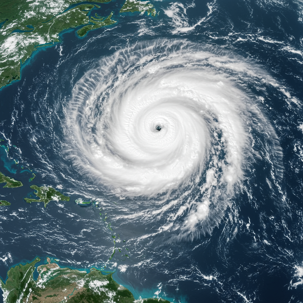
Hurricane Erin has made history with its stunning and swift transformation. In just over 24 hours, this formidable storm catapulted from a Category 1 hurricane with 75 mph winds to a terrifying Category 5, boasting nearly 160 mph sustained winds. This dramatic surge firmly places Erin in the record books. It represents one of the fastest-strengthening Atlantic hurricanes ever observed, and potentially the most rapid intensification rate for any storm occurring before September 1st.
Rapid intensification is a phenomenon where a hurricane gains at least 35 mph in wind speed within a 24-hour period. Historically, extreme rapid intensification often occurs later in the hurricane season, typically in September and October. However, Erin’s early-season burst underscores how quickly these storms can become critical threats, leaving little time for preparation. Its wind speeds significantly exceed the 157 mph threshold required for a Category 5 designation on the Saffir-Simpson Hurricane Wind Scale.
A Rare Category 5 and the Warming World Connection
The sheer strength of Hurricane Erin is striking. It is only the 43rd Category 5 hurricane ever recorded in the Atlantic basin. Even more notably, Erin is the 11th Category 5 storm to form in the Atlantic since 2016, an unusually high concentration of such powerful events in recent years. This suggests that achieving peak strength is becoming easier for tropical systems.
Its early formation as a Category 5 is also highly unusual. While mid-August marks the typical peak of hurricane activity, the strongest storms usually emerge later in the season, and rarely outside the Gulf of Mexico. The 2025 Atlantic hurricane season now marks the fourth consecutive year to feature a Category 5 storm, following the impactful Hurricanes Beryl and Milton in 2024. This pattern strongly links to broader climate trends. As global oceans and the atmosphere continue to warm due to fossil fuel pollution, the conditions for such extreme weather events become more frequent. Hurricane Erin serves as a stark example of the increasing extremes occurring in a warming world.
Erin’s Projected Path and Alarming Size Expansion
Currently churning through the Atlantic Ocean north of the Caribbean, Hurricane Erin is largely expected to avoid a direct hit on major landmasses. Its anticipated trajectory will take it north of Puerto Rico, before curving north-northeast into the open Atlantic, tracking between the US East Coast and Bermuda next week. Despite this path, the storm’s reach is poised to expand dramatically. Forecasters anticipate Erin’s powerful wind field could double or even triple in size over the coming days.
This significant growth means a much wider area will experience dangerous conditions. Even without direct landfall, an enlarged storm system generates far-reaching hazards. This expansion extends the threat zone for hazardous marine conditions and coastal impacts, demanding vigilance from a broader range of communities.
Immediate Impacts: Caribbean and Coastal Warnings
The immediate effects of Hurricane Erin have already been felt across parts of the Caribbean. The storm passed just north of the Leeward Islands, the Virgin Islands, and Puerto Rico over the weekend. While direct landfalls were largely averted, tropical alerts were issued for several areas. The US Coast Guard captain for the port of San Juan took extraordinary measures, directing the closure of ports in St. Thomas, St. John, and six seaports in Puerto Rico to inbound vessel traffic.
These islands experienced rough seas, dangerous rip currents, gusty winds, and periods of heavy rain. Some locations could see 2 to 4 inches of rainfall, with isolated totals potentially reaching 6 inches. Such intense precipitation raises serious concerns for flash flooding and mudslides, particularly in mountainous or low-lying areas. Beyond the Caribbean, the National Hurricane Center (NHC) warns that life-threatening surf and rip currents are expected to impact the beaches of the Bahamas, much of the US East Coast, and Atlantic Canada in the coming week.
Long-Term Outlook: East Coast Vigilance
Looking further ahead, meteorologists project Hurricane Erin will continue its northwestward movement, generally remaining east of the Bahamas. By early next week, the storm is forecast to slow down and execute a northward turn, positioning itself between Bermuda and the U.S. East Coast. Current modeling largely suggests Erin will stay hundreds of miles offshore, preventing a direct hit on the continental United States.
However, significant indirect impacts are still anticipated. Large waves and life-threatening rip currents are forecast to reach the US East Coast from approximately August 20th to 27th. These conditions pose severe risks not only to swimmers but also to coastal properties due to potential erosion. North Carolina’s Outer Banks, for instance, could experience waves of 8 to 12 feet, while parts of South Carolina and Virginia might see waves up to 6 feet. A crucial factor in keeping Erin offshore is a cold front pushing off America’s coast, which is helping to steer the storm away.
The 2025 Atlantic Hurricane Season in Context
Hurricane Erin marks a significant milestone as the first major hurricane of the 2025 Atlantic season. While four other named systems — Andrea, Barry, Chantal, and Dexter — had roamed the Atlantic basin before Erin, none of them intensified beyond tropical storm strength. Erin’s rapid development quickly shifted the seasonal narrative.
Typically, the first hurricane of the Atlantic season forms around August 11th. While Erin was slightly behind this average, its intensity and timing are nonetheless remarkable, especially when compared to recent seasons that have seen earlier major hurricane arrivals. The busiest stretch of the hurricane season generally spans from mid-August to mid-October, and forecasters predict an above-average level of tropical activity for 2025. This forecast underscores the need for continued vigilance as the season progresses.
Preparation and Safety Amidst Extreme Weather
The development of Hurricane Erin serves as a critical reminder for all coastal and even inland communities to review their hurricane preparedness plans. Even without a direct strike, the far-reaching impacts of such powerful storms can be devastating. Residents in affected areas, particularly those in the Caribbean, Bahamas, and along the US East Coast, must remain vigilant.
It is essential to monitor official forecasts from the National Hurricane Center and local authorities closely. Heed all warnings regarding rough surf, rip currents, and potential flooding. Secure outdoor items, have emergency kits ready, and know evacuation routes if advised. Understanding the evolving nature of such powerful systems and taking proactive measures can mitigate risks and protect lives.
Frequently Asked Questions
What makes Hurricane Erin’s rapid intensification so unusual?
Hurricane Erin exhibited an exceptionally rapid intensification, jumping from a Category 1 to a Category 5 hurricane in just over 24 hours with winds surging from 75 mph to nearly 160 mph. This rate of strengthening is among the fastest on record for any Atlantic storm and potentially the quickest before September 1st. This early-season, extreme intensification, fueled by warmer-than-normal sea surface temperatures, is increasingly linked to climate change, making Erin a striking example of a trend toward more powerful and rapidly developing hurricanes.
Where are the primary areas currently impacted by Hurricane Erin, and what are the specific threats?
Hurricane Erin has passed just north of the Leeward Islands, Virgin Islands, and Puerto Rico, bringing heavy rainfall (2-6 inches), gusty winds, rough seas, and dangerous rip currents to these areas. While avoiding direct major landfalls, its broader impacts are significant. Life-threatening surf and rip currents are now expected along the beaches of the Bahamas, much of the US East Coast, and Atlantic Canada. Port closures have also been enacted in the US Virgin Islands and Puerto Rico as a safety precaution.
How does the projected size increase of Hurricane Erin affect coastal communities, even without direct landfall?
Even without making direct landfall, Hurricane Erin’s projected doubling or tripling in size significantly expands its impact zone. A larger storm creates a more widespread and powerful wind field, generating enormous waves and life-threatening rip currents that can reach hundreds of miles from the storm’s center. This means areas like the US East Coast and Atlantic Canada will experience dangerous surf, coastal erosion, and hazardous swimming conditions, even though the storm’s core remains offshore. Preparedness for these indirect but severe impacts is crucial.