Urgent flash flood emergency Hits Ruidoso, New Mexico
Residents in Ruidoso, New Mexico, faced an immediate and severe threat on Tuesday, July 8, 2025, as the National Weather Service (NWS) declared a flash flood emergency. Authorities issued urgent warnings for everyone in the area to seek higher ground without delay. The situation rapidly escalated due to intense rainfall, overwhelming the landscape and waterways. Harrowing video footage captured the raw power of the floodwaters, including one instance where an entire home was ripped from its foundation and swept away down a raging current. This event underscores the unpredictable and dangerous nature of flash flooding, particularly in vulnerable regions.
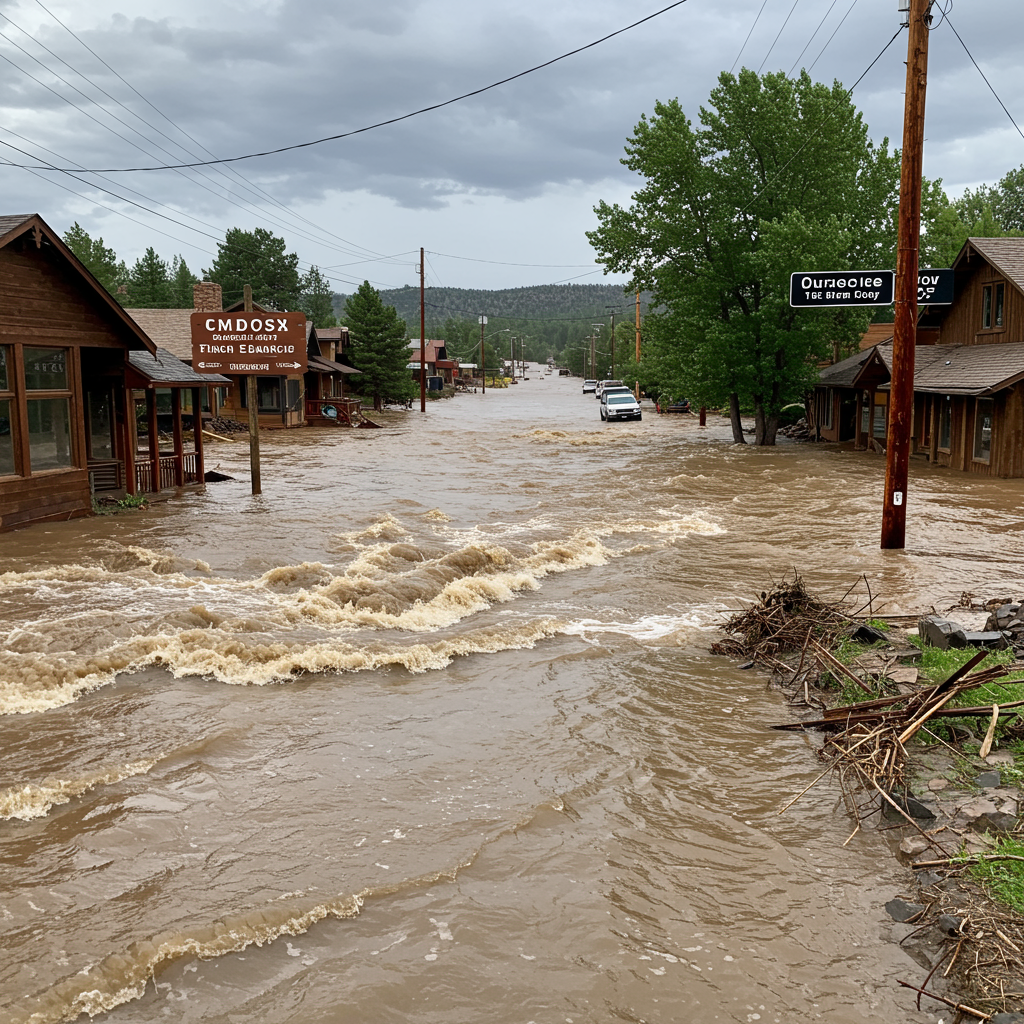
Rapid River Rise and Devastating Impact
The sheer speed and intensity of the flooding were significant factors in the emergency. The Rio Ruidoso river, a central waterway in Lincoln County, experienced an almost unbelievable surge. Reports indicate the river level rose approximately 19 feet in mere minutes at the Hollywood gauge, setting a new record level that exceeded the previous mark by several inches. Along its 30-mile stretch, real-time data showed water levels “extremely above” historic averages.
This rapid rise caused widespread damage. Swift water rescue teams became crucial, performing at least 85 rescues in the Ruidoso area. Many individuals were pulled from homes and vehicles trapped by the fast-moving water. Specific locations like the Gavilan Trailer Park saw ongoing rescue missions. While preliminary reports indicated three people were treated for injuries by Tuesday night, the exact number of fatalities was unconfirmed, and an unspecified number of residents remained unaccounted for, highlighting the chaotic nature of the event. Infrastructure was also severely impacted, with about a dozen roads becoming impassable due to accumulating debris, hindering access and complicating rescue efforts.
Warnings Issued Ahead of Critical Flooding
The National Weather Service worked to alert the public as the situation developed. A flood watch for the South Central Mountains, which includes Ruidoso, was initially issued early Tuesday morning at 2:46 a.m. MT, signaling the potential for flooding later in the day. As conditions worsened, a flash flood warning specifically for the South Fork burn scar in Lincoln County was issued at 2:12 p.m. This warning included a “considerable” flooding tag, designed to automatically trigger Wireless Emergency Alerts on mobile devices in the affected zone.
Just about 30 minutes later, the NWS upgraded the warning to a flash flooding emergency. This classification is reserved for “exceedingly rare” situations where a severe threat to human life is imminent or occurring. The swift progression from watch to warning to emergency in a short timeframe reflects the rapid onset characteristic of flash floods, which can make timely public notification incredibly challenging despite forecasters’ best efforts.
Wildfire Burn Scars Magnify Flood Risk
A critical, compounding factor behind the severity of the Ruidoso flash flood was the lasting impact of recent wildfires. Much of the region, including areas along the Rio Ruidoso, had been severely burned by the South Fork and Salt fires in June 2024. These fires devastated the landscape, leading to two fatalities and destroying hundreds of homes just weeks before the flooding.
Wildfires dramatically alter the environment’s ability to handle rainfall. They burn away vegetation and destroy the root systems that typically help hold soil in place and absorb water. This leaves the ground hard, compacted, and unable to soak up moisture effectively. Consequently, rainwater runs off rapidly across the surface, collecting debris and forming powerful, fast-moving torrents – the perfect recipe for catastrophic flash floods. Experts warn that burn scars can significantly increase flash flood risks for at least two years post-fire, making the Ruidoso area exceptionally vulnerable to even moderate rainfall amounts.
Understanding the Speed and Danger of Flash Floods
Flash floods are among the most dangerous weather phenomena. They occur rapidly, often with little warning, and can turn normally dry creek beds or small streams into raging rivers in minutes. Unlike typical river floods that develop over hours or days, flash floods are typically triggered by intense rainfall over a short period, or by events like dam failures or sudden ice jams.
Forecasting the precise location and timing of the heaviest rainfall that triggers flash floods remains a significant challenge for meteorologists. While agencies like the NWS can identify areas at risk based on atmospheric conditions, topography, and soil saturation (including burn scars), pinpointing exactly where and when the most dangerous flooding will occur can be incredibly difficult in real-time. This inherent unpredictability highlights why emergency warnings, once issued, demand immediate action from the public.
The Challenge of Warning Communication
Issuing an accurate warning is only the first step; ensuring that urgent messages reach everyone at risk is equally critical. This is often referred to as the “last mile” problem in emergency management. Factors such as the time of day (especially overnight events), language barriers, reliance on specific technologies (like mobile alerts), and individuals not being aware of the danger or not taking it seriously can impede effective communication.
In rapidly evolving events like the Ruidoso flash flood, residents need to be vigilant and prepared to act quickly based on official alerts. Understanding evacuation zones, having a plan to reach higher ground, and staying informed through multiple channels (local authorities, NWS alerts, media) are vital steps individuals can take to protect themselves and their families when flash flood watches or warnings are in effect.
Moving Forward After the Flood
As floodwaters receded, the focus shifted to cleanup and accounting for those still missing. The devastation serves as a stark reminder of the power of nature, amplified in landscapes altered by wildfire. The Ruidoso community, already reeling from the June fires, now faces another layer of recovery. Efforts to assess the full extent of the damage, repair infrastructure, and support affected residents are ongoing. For communities in burn scar areas, maintaining a heightened awareness of flood risk and heeding weather service warnings will remain critically important for the foreseeable future.
Frequently Asked Questions
What specifically caused the flash flood emergency in Ruidoso?
The Ruidoso flash flood emergency on July 8, 2025, was caused by intense, rapid rainfall over the area. A major contributing factor was the presence of recent burn scars from the South Fork and Salt wildfires in June 2024. These fires left the ground unable to absorb water, causing rain to run off quickly and violently, overwhelming rivers and streams like the Rio Ruidoso.
Where did the most severe flooding occur in the Ruidoso area?
The flooding significantly impacted areas along the Rio Ruidoso river throughout Lincoln County. Specific locations mentioned as being severely affected included the Gavilan Trailer Park and areas within the village of Lincoln. The Hollywood gauge on the Rio Ruidoso recorded a record-breaking water level, indicating extreme conditions in that vicinity.
What actions should residents take during a flash flood emergency?
During a flash flood emergency declared by the National Weather Service, residents should immediately move to higher ground. Do not attempt to walk or drive through floodwaters; even shallow water can be dangerous due to hidden currents or debris. Follow instructions from local authorities, stay informed via emergency alerts and local news, and be prepared to evacuate if advised.
Conclusion
The flash flood emergency in Ruidoso on July 8, 2025, served as a tragic demonstration of nature’s force, particularly in an environment made vulnerable by recent wildfires. The rapid rise of the Rio Ruidoso and the swift, destructive power of the water highlighted the immediate danger faced by residents. While the National Weather Service issued escalating warnings, the event also underscored the inherent challenges in forecasting and communicating the threat of such sudden, intense weather events. As the community begins the process of recovery, the emphasis remains on vigilance, preparedness, and respecting the urgent warnings issued during severe weather.