Central Texas, often called “flash flood Alley,” recently witnessed a tragic and historic flood event. The Guadalupe river, a beloved waterway, transformed into a raging torrent with shocking speed. This sudden surge claimed over 80 lives and devastated communities, particularly impacting a local summer camp. Understanding why this river floods so rapidly and the unique characteristics of this region is crucial. This deep dive explores the deadly combination of factors that make the Texas Hill Country uniquely vulnerable to such catastrophic events.
The Unprecedented Speed of the Guadalupe River Flood
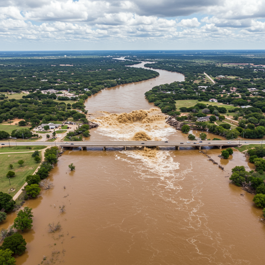
The severity of the recent Independence Day 2025 flood on the Guadalupe River was marked by its incredible speed. State officials reported an astonishing rise of 26 feet in just 45 minutes during the early hours of Friday. River gauge data near Hunt showed the river swelling by 20 feet in merely three hours. This dramatic change turned a typically calm stream into a powerful, destructive force in minutes.
The U.S. Geological Survey (USGS) documented the river’s discharge peaking at a staggering 111,000 cubic feet per second. A New York Times analysis noted the flow rate surged from a wadable 10 cubic feet per second to 120,000 cubic feet per second in under 10 hours, exceeding the average flow of Niagara Falls. This rapid escalation overwhelmed communities along the riverbanks.
The flood’s intensity contributed to catastrophic damage across Central Texas. Over 104 fatalities were reported across multiple counties, with 84 occurring in Kerr County alone, the heart of the flood zone. This human toll included the heartbreaking loss of at least 27 campers and counselors at Camp Mystic, a girls’ summer camp situated directly on the river. The sheer force of the water destroyed infrastructure, homes, and vehicles, leaving a path of widespread devastation.
Where Does the Guadalupe River Flow?
The Guadalupe River is a significant waterway winding through Central and south-central Texas. Its journey begins in Kerr County, where it’s fed by both North and South Forks. This spring-fed stream then flows eastward. It passes through Kendall and Comal Counties before turning south. Its path eventually leads it to the Gulf of Mexico via San Antonio Bay. The river stretches approximately 250 miles in total length.
As the fourth-largest river basin entirely within Texas, the Guadalupe River system drains a vast area. This basin collects rainfall and runoff from the Texas Hill Country down to the coast. Its extensive network of tributaries and its path through varied terrain play a significant role in the region’s hydrology and, unfortunately, its flood risk.
Understanding ‘Flash Flood Alley’
The area surrounding the Guadalupe River, particularly within the Texas Hill Country, has long been recognized for its high flash flood potential. This vulnerability has earned the region the ominous nickname “Flash Flood Alley.” This curved geographic zone is roughly 300 miles long and about 50 miles wide. It extends across central and south-central Texas, stretching from areas north of Dallas down to southwest of San Antonio.
“Flash Flood Alley” is considered one of the most flood-prone regions in the entire United States. The Guadalupe River basin specifically is often cited as one of the country’s most dangerous areas for sudden and severe flooding. This high-risk classification stems from a unique and unfortunate alignment of geographical and meteorological factors.
The Three Key Factors Driving Flash Floods
The rapid, devastating floods seen in Flash Flood Alley are not random occurrences. They result from a specific interplay of weather patterns, geology, and topography. These three elements combine to create a natural environment where water levels can rise dramatically with little warning.
Intense Rainfall Patterns
One primary driver is the region’s susceptibility to heavy, sudden rainstorms. Flash Flood Alley sits in a unique position. It’s where cold, dry air masses pushing south from the northern United States frequently collide. These meet warm, moist air flowing inland from the Gulf of Mexico. This convergence often leads to the formation of intense thunderstorms. These storms can produce extremely high rainfall rates, sometimes three to four inches per hour, dumping massive amounts of water in a short period over a concentrated area. Remnants of tropical systems, like former Tropical Storm Barry contributing to the 2025 flood, can further exacerbate this, providing exceptional levels of moisture.
Impermeable Rocky Soil
The geology beneath Flash Flood Alley also plays a critical role. The Texas Hill Country is characterized by shallow soil lying atop significant deposits of limestone bedrock. This rock type, and the clay-rich, thin soil cover, is not porous. It doesn’t absorb water effectively. When heavy rain falls, the ground quickly becomes saturated. Instead of soaking into the earth, most of the water becomes surface runoff. This rapid runoff quickly flows across the land. It then channels directly into creeks and rivers, causing water levels to rise almost instantly rather than being buffered by ground absorption.
Steep and Hilly Terrain
Finally, the topography of the region accelerates the flow of water. The area features rugged hills, cliffs, and steep valleys. This includes the Balcones Escarpment, a series of fault lines creating a dramatic change in elevation. This landscape acts like a funnel. Rainfall that becomes rapid surface runoff on the hillsides rushes downhill quickly. It converges and channels into the lower-lying riverbeds and creek beds below. This rapid collection and channeling of water leads to the swift and dramatic surges characteristic of flash floods, pushing river levels to dangerous heights with extreme speed and force.
The Devastating Human and Property Impact
The 2025 Guadalupe River flood tragically highlighted the dangers of Flash Flood Alley. The death toll climbed rapidly, reaching over 104 across multiple counties, with Kerr County experiencing the greatest loss of life. The tragedy at Camp Mystic, where campers and counselors were swept away, became a focal point of the disaster. The speed and unexpected nature of the flood made timely evacuations incredibly difficult.
The physical destruction was immense. Homes, businesses, RVs, and vehicles were washed away or severely damaged. Bridges collapsed, and roads were rendered impassable. Rescue efforts were immediate and extensive, involving hundreds of personnel using helicopters, boats, and high-water vehicles. Over 850 people were rescued from the floodwaters. Officials quickly issued disaster declarations at both state and federal levels to provide aid to the affected areas. The event underscored the vulnerability of communities built along these waterways and the challenges of warning systems when water rises so precipitously.
A History of Devastating Floods
The recent flood, while catastrophic, is part of a recurring pattern in Flash Flood Alley. River streamflow records show major floods impacting the Guadalupe River basin for over a century, occurring roughly once a decade. Past events serve as grim reminders of the region’s inherent risks.
In July 1987, slow-moving thunderstorms stalled over the upper Guadalupe basin, dropping inches of rain. A surge swept through, tragically killing 10 people at a Christian camp near Comfort. Tropical Storm Amelia in the summer of 1978 caused widespread flooding in south-central Texas, dropping up to four feet of rain in some areas and resulting in 33 fatalities statewide. Even further back, a hurricane remnant in September 1921 caused immense flooding with reports of 40 inches of rain in Thrall, leading to 215 deaths across the region, including along the Guadalupe basin. These historical events demonstrate that the rapid and deadly nature of the 2025 flood is deeply rooted in the environmental characteristics of Flash Flood Alley.
Frequently Asked Questions
Why does Flash Flood Alley experience such fast and dangerous floods?
Flash Flood Alley’s extreme flood risk comes from a perfect storm of natural factors. Intense thunderstorms drop heavy rain quickly. The ground, made of shallow, clay-rich soil over limestone, doesn’t absorb water well, causing rapid runoff. This runoff then rushes down the region’s steep, hilly terrain, funneling into rivers and creeks. This combination leads to incredibly fast and dramatic rises in water levels, turning calm streams into dangerous torrents in minutes.
Where is Flash Flood Alley located in Texas?
Flash Flood Alley is a curved geographic region located in central and south-central Texas. It encompasses the Texas Hill Country and stretches roughly from north of Dallas southwest towards San Antonio. Key river basins within this area include the Guadalupe River and the Colorado River basins. It’s known for its rugged landscape and high susceptibility to sudden flooding.
What was the impact of the recent 2025 Guadalupe River flood?
The July 2025 flood on the Guadalupe River was catastrophic. It caused widespread destruction along the river and contributed to over 104 fatalities across Central Texas, with 84 deaths in Kerr County alone. This included the tragic loss of at least 27 lives at Camp Mystic. The floodwaters rose with unprecedented speed and force, destroying homes, businesses, vehicles, and infrastructure. Hundreds of people required rescue from the rising waters.
Conclusion
The catastrophic flood on the Guadalupe River in 2025 serves as a stark and tragic reminder of the inherent dangers posed by Texas’ “Flash Flood Alley.” The unique combination of weather patterns that deliver intense rainfall, geology that prevents water absorption, and topography that accelerates runoff creates an environment uniquely susceptible to sudden and deadly flash floods. While rescue and recovery efforts highlighted the resilience of Texas communities, understanding the natural forces at play is vital for future preparedness and safety in this beautiful yet hazardous region. The events underscore the critical need for awareness of these natural risks for anyone living in or visiting the Texas Hill Country.