NASA’s Lunar Reconnaissance Orbiter (LRO) has successfully captured images of the final resting place of ispace’s Resilience lunar lander. The Japanese spacecraft, which attempted a touchdown on June 5, 2025, tragically ended its mission with a hard impact on the lunar surface.
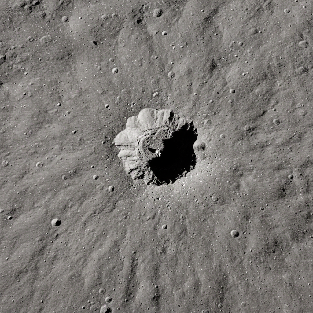
The images from LRO reveal a distinctive dark smudge surrounded by a subtle bright halo at the crash site, visual evidence of the vehicle’s forceful encounter with the moon’s regolith.
A Mission’s End in the Sea of Cold
The Resilience mission, ispace’s second attempt to achieve a soft lunar landing, launched aboard a SpaceX Falcon 9 rocket on January 15, 2025. Following an energy-efficient trajectory, the lander spent months in space before reaching the moon. The spacecraft was designed as an upgrade to ispace’s first lander, which failed in April 2023 due to a sensor issue during descent – a problem the company aimed to rectify with Resilience’s improved software.
Resilience was targeting a precise location within Mare Frigoris, the “Sea of Cold,” a vast volcanic plain situated near the moon’s northern polar region. This ancient area, formed over 3.5 billion years ago by massive basalt eruptions, is characterized by its dark surface and large-scale faults known as wrinkle ridges. The planned landing coordinates were approximately 60.5 degrees north latitude and 4.6 degrees west longitude, near the center of this geological feature.
However, shortly after initiating its landing sequence on June 5, ispace’s Mission Control Center lost communication with Resilience. The team quickly concluded that the lander had been lost, marking the company’s second consecutive failed lunar landing attempt.
Orbital Evidence of the Impact
NASA’s powerful Lunar Reconnaissance Orbiter later located and imaged the impact site. Mark Robinson, the principal investigator for the LRO Camera (LROC), offered insight into the features visible in the orbital photos.
He explained that the dark smudge was created as the descending vehicle excavated and redistributed the shallow lunar soil, or regolith, upon impact. The faint bright halo surrounding the smudge is attributed to low-angle regolith particles scouring the delicate surface around the point of collision.
The crash spot identified by LRO lies roughly 1.5 miles (2.4 kilometers) away from the specific coordinates ispace had targeted. While this might seem close, Robinson noted that specifying a lunar location to one decimal place in latitude and longitude still encompasses a considerable area, approximately 19 miles (30 km), highlighting the challenge of pinpoint precision on the lunar surface.
Lost Payloads
Besides the lander itself, the crash also resulted in the loss of valuable payloads onboard. This included the Tenacious microrover, a small, 11-pound (5 kg) wheeled vehicle developed by ispace’s European subsidiary in Luxembourg. Tenacious was equipped with a shovel for sample collection and an imaging camera. Notably, it also carried a unique piece of cargo: Mikael Genberg’s “Moonhouse,” a small replica of traditional Swedish red-and-white homes, intended to be deposited on the moon as an art project.
The LRO images provide a stark, silent testament to the challenging nature of lunar landings and the risks involved in commercial space exploration efforts like those undertaken by ispace.