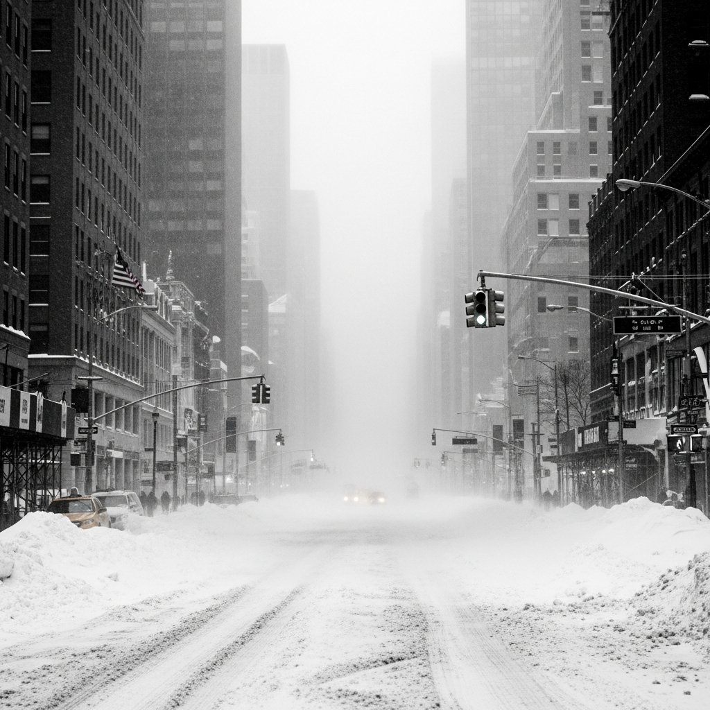
The Tri-State Area is currently battling a historic and rapidly intensifying nor’easter, dubbed Winter Storm Hernando, unleashing a potent combination of heavy, wet snow, ferocious winds, and life-threatening blizzard conditions. Initially underestimated, this powerful weather system has escalated into potentially the worst winter storm the region has experienced in a decade, prompting widespread emergency declarations, travel bans across New York City and New Jersey, and projections of up to two feet of snow in many areas. Residents are urged to avoid all non-essential travel and brace for significant disruptions, including extensive power outages and coastal flooding, as the storm’s most severe impacts unfold from Sunday evening into Monday, February 23, 2026.
Tri-State Gripped by a “Blockbuster” Blizzard Warning
What began as a forecast for minor snowfall rapidly transformed into a full-blown “blockbuster snowstorm,” placing approximately 41 million people across the Northeastern United States under active blizzard warnings. For the Tri-State region, this means all five boroughs of New York City, Long Island, the Lower Hudson Valley, most of New Jersey, and southern Connecticut are under official blizzard warnings. This extensive warning, covering all 29 counties in the ABC7 viewing area, is a phenomenon not seen since the Blizzard of 1996, with some meteorologists drawing parallels to the severe upper-air setup of the Blizzard of 1978.
Unprecedented Snowfall & Wind Forecasts
Forecasters predict widespread snowfall totals ranging from 12 to 18 inches across much of the region. However, specific localized areas are expected to see significantly more, with eastern Long Island, the South Shore of Nassau County, parts of the Jersey Shore, and even sections of New York City potentially accumulating 18 to 24-plus inches. Some areas further out on Long Island could even reach up to two feet of snow. Snowfall rates are intensifying, with expectations of 2 to 3 inches per hour, and coastal areas could experience intense bursts of up to 4 inches per hour, especially between Sunday night and Monday morning.
The storm is also bringing tropical storm-force winds. Gusts are forecast to reach 40-60+ mph, particularly at the coast, with New Jersey Governor Mikie Sherrill warning of winds potentially hitting 60 mph. The East End of Long Island could experience peak gusts of 70 mph. These powerful winds, combined with heavy, wet snow, create dangerous whiteout conditions, reducing visibility to less than a quarter-mile for at least three consecutive hours – the official criteria for a blizzard warning from the National Weather Service. This rare combination even raises the possibility of “thundersnow” in some areas.
Widespread Travel Paralysis Across the Region
The severe weather has prompted an unprecedented wave of travel restrictions and public transit suspensions across New York, New Jersey, and Connecticut. Officials have issued stark warnings, emphasizing that travel during peak blizzard conditions could be perilous, even life-threatening. The goal is to keep roads clear for emergency services and snow removal operations.
Road Restrictions & Public Transit Halts
Multiple travel bans are currently in effect:
New York City: Mayor Zohran Mamdani declared a city-wide state of emergency, including a ban on all non-essential traffic (cars, trucks, scooters, e-bikes) from 9 p.m. Sunday until noon Monday.
Long Island: Travel ban from 9 p.m. Sunday to 9 a.m. Monday.
Westchester County: County-wide road ban began 9 p.m. Sunday.
Rockland County: All non-essential vehicles advised off county roads by 6 p.m. Sunday, with the ban continuing through Monday.
New Jersey: A conditional full travel ban on all roads, except the Turnpike, is in effect from 9 p.m. Sunday to 7 a.m. Monday. Governor Mikie Sherrill also noted that this marks New Jersey’s first statewide blizzard since 1996.
Connecticut: Governor Ned Lamont declared a state of emergency and enacted a commercial vehicle travel ban starting 5 p.m. Sunday.
Mass transit systems have been severely impacted. NJ Transit suspended bus, light rail, and Access Link services by 6 p.m. Sunday, with all rail service halted by 9 p.m. The Long Island Rail Road (LIRR) announced a complete system shutdown starting 1 a.m. Monday to facilitate snow clearing and manage extreme winds. Metro-North is operating on an hourly schedule for its main lines on Monday, with branch lines running weekend schedules. NYC subways are on a modified schedule, and MTA buses have been fitted with chains, while NYC ferry services ended early.
Air Travel Chaos & Commuter Impact
Air travel has descended into chaos, with over 1,600 flights canceled at NYC’s three major airports (LaGuardia, JFK, Newark Liberty) by Sunday morning, and AccuWeather estimating more than 2,500 cancellations nationwide. These New York-area airports reported the highest number of cancellations and delays globally. Beyond transit, the storm has even led to the cancellation of Broadway shows in New York City for Sunday evening, highlighting the widespread disruption. Commuters face unprecedented challenges, with authorities strongly advising against any non-essential travel until conditions significantly improve.
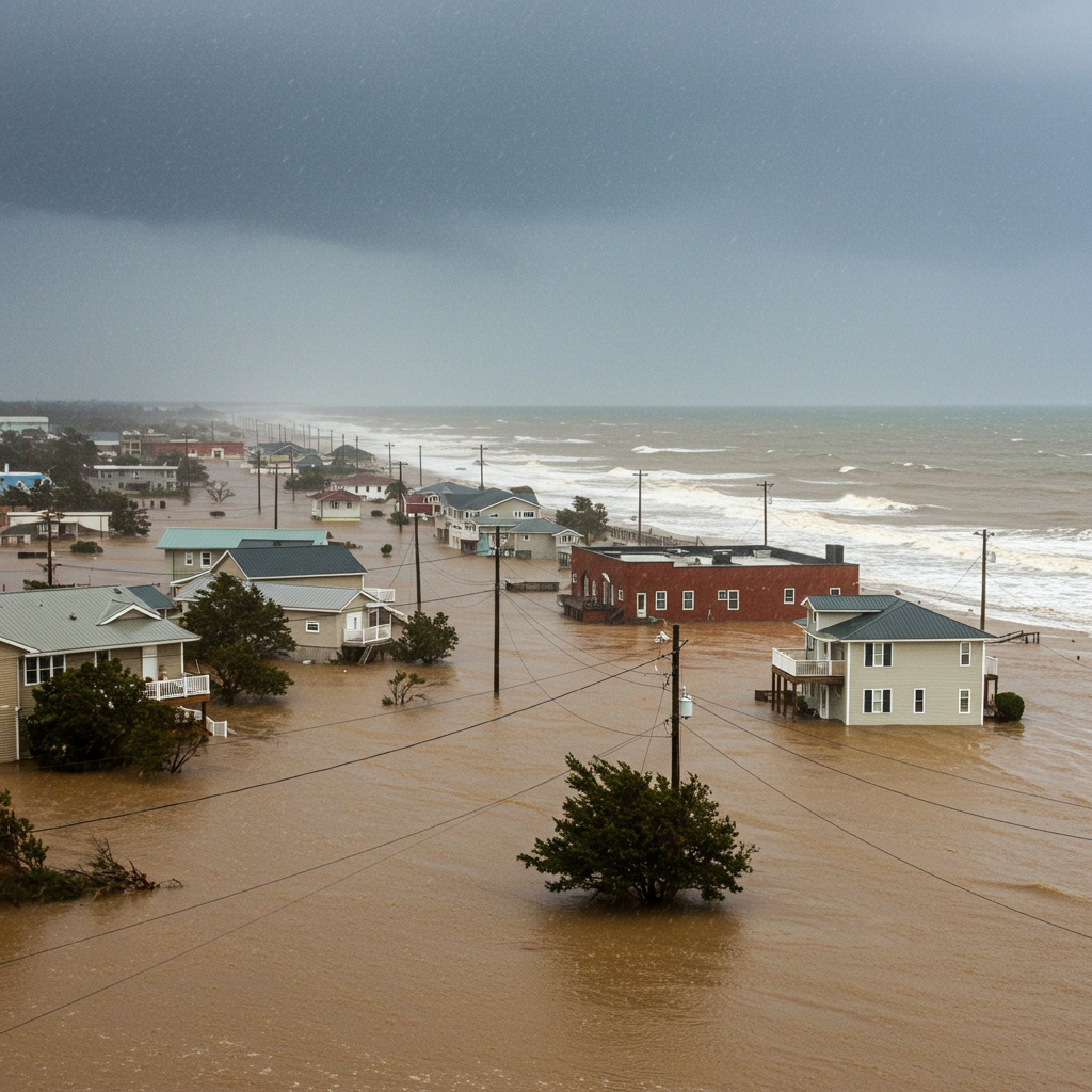
Critical Impacts: Power Outages & Coastal Flooding
Beyond the immediate travel disruptions, the “Blizzard of 2026” poses significant threats to infrastructure and coastal communities, with widespread power outages and coastal flooding high on the list of concerns.
Utilities Brace for Extensive Outages
The combination of heavy, wet snow accumulating on trees and power lines, coupled with powerful wind gusts, is a recipe for extensive power outages. Utility companies like Orange & Rockland, ConEdison, PSE&G, and NYSEG have mobilized emergency crews, tree-cutting teams, and mutual aid workers to address anticipated service interruptions. Already by Sunday night, Jersey Central Power & Light reported over 15,000 customers without electricity in New Jersey alone, a number expected to climb dramatically as the storm peaks. Residents are strongly advised to charge all electronic devices and prepare for potential multi-day power losses.
Coastal Communities Under Flood Threat
Coastal areas, particularly along the Jersey Shore, the South Shore of Long Island, and waterfront towns in southern Westchester County and Connecticut, are under coastal flood warnings. The highest impact is expected during the post-midnight high tide on Monday, coinciding with the storm’s strongest winds. Projections indicate 1 to 3.5 feet of inundation possible in vulnerable back-bay areas, potentially closing roads and causing property damage. Communities like Nyack and Yonkers have declared individual snow emergencies, restricting parking to aid snow removal and manage potential flooding.
Government Response & Community Preparedness
In response to the escalating crisis, state and local governments have activated extensive emergency protocols, deploying resources and issuing critical guidance to ensure public safety. This storm marks NYC’s first blizzard warning since 2017 and Long Island’s first since 2022, underscoring its rare intensity.
Emergency Declarations & Resource Deployment
New York Governor Kathy Hochul and New Jersey Governor Mikie Sherrill both declared states of emergency across their respective states, including over 20 counties in New York, facilitating the deployment of emergency resources. Governor Hochul activated 100 National Guard members and 25 vehicles to assist with storm response across downstate regions. New York City’s Department of Sanitation (DSNY) has deployed approximately 2,300 plows and 2,600 sanitation workers per shift, with a publicly available plow tracker, “PLOWNYC,” to monitor progress.
State courthouses in several counties, including Rockland, Westchester, Orange, Putnam, and Long Island, will be closed Monday. New York Attorney General Letitia James issued warnings against price gouging on essential goods and services, urging citizens to report any instances of unfair pricing during the emergency.
School Closures & Warming Centers
For many, this storm means an old-fashioned snow day. New York City public schools announced a full snow day for Monday, securing a waiver from the state education commissioner – marking NYC’s first traditional snow day without remote learning since 2019. Newark Public Schools and numerous universities in the Boston area also declared closures for Monday. To ensure public safety, over 50 warming centers have been established across NYC’s five boroughs, including hospitals and Department of Homeless Services sites, implementing “Code Blue” protocols allowing shelter access without traditional intake. Similar warming centers are available in Westchester and Rockland counties.
Essential Safety Measures & What’s Next
As the Tri-State Area navigates the height of this historic blizzard, adherence to safety guidelines is paramount. Officials repeatedly stress that the “worst is yet to come,” with a rapid transition to heavier, wetter snow expected.
Stay Home: Avoid all non-essential travel. Roads are hazardous, and visibility is near zero.
Prepare for Outages: Charge all phones and electronic devices. Have flashlights, extra batteries, and an emergency kit ready.
Check on Neighbors: Particularly the elderly and vulnerable, to ensure their safety and well-being.
Vehicle Safety: If travel is unavoidable, keep a winter survival kit in your vehicle (blankets, food, water, first-aid, shovel, charging bank) and stay with your vehicle if stranded.
- Stay Informed: Monitor local news for ongoing updates on conditions, travel bans, and service resumptions.
- www.nbcnewyork.com
- www.cbsnews.com
- abc7ny.com
- www.nbcnews.com
- www.lohud.com
While conditions are expected to gradually improve by midday Monday, with snow tapering off to lighter bursts in the late afternoon and evening, strong winds are projected to persist well into the day. This “Blizzard of 2026” has a “fighting chance” of ranking among Central Park’s top 10 biggest snowstorms ever recorded, cementing its place in regional history.
Frequently Asked Questions
What defines a blizzard warning and why is this storm so significant for the Tri-State?
A blizzard warning from the National Weather Service signifies sustained winds or frequent gusts of at least 35 mph, combined with visibility of a quarter-mile or less due to falling or blowing snow, persisting for three hours or more. This storm is exceptionally significant for the Tri-State area because it meets these criteria across a vast region, potentially bringing snowfall totals of 18-24+ inches in many areas, accompanied by wind gusts up to 70 mph. Officials have labeled it as potentially the worst winter storm in a decade, marking New Jersey’s first statewide blizzard since 1996 and New York City’s first blizzard warning since 2017. Its intensity and widespread impact make it a truly historic event, with parallels drawn to blizzards from 1978 and 1996.
Where can Tri-State residents find real-time updates on travel bans and service suspensions?
Residents should continuously monitor official government channels and local news outlets for the latest real-time updates. This includes official announcements from New York City Mayor Zohran Mamdani, New York Governor Kathy Hochul, New Jersey Governor Mikie Sherrill, and Connecticut Governor Ned Lamont. Specific transit updates are available from NJ Transit, Long Island Rail Road (LIRR), Metro-North, and the MTA for subway and bus services. For road conditions, check state Department of Transportation websites, and NYC’s Department of Sanitation offers a “PLOWNYC” tracker. Local news websites like NBC New York, CBS New York, and ABC7NY are also providing continuous live coverage and official advisories.
What essential safety steps should residents take during a severe blizzard like this?
During a severe blizzard, prioritizing safety is crucial. First, avoid all non-essential travel; roads are extremely hazardous due to whiteout conditions and heavy snow, and travel bans are in effect. Second, prepare for potential power outages by fully charging all electronic devices, having flashlights with fresh batteries, and an emergency kit with blankets, non-perishable food, and water. Third, check on vulnerable neighbors, especially the elderly, to ensure they are safe and warm. If absolutely necessary to travel, carry a comprehensive winter survival kit in your vehicle and stay with your car if you become stranded.