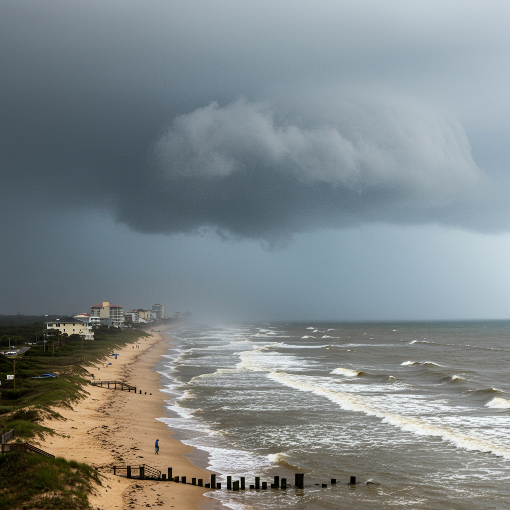
The third named storm of the 2025 Atlantic hurricane season, tropical Storm Chantal, has made landfall along the South Carolina coast, bringing immediate threats of heavy rain, potential flash flooding, and dangerous coastal conditions. The storm, which formed quickly off the Southeast U.S. coast, came ashore early Sunday morning, July 6, 2025, near Litchfield Beach.
While the storm is expected to weaken rapidly now that its center is over land, officials and weather experts are urging residents in the affected areas to remain vigilant. The most significant impacts are anticipated to be felt well after landfall as the storm moves inland, particularly due to the storm’s lopsided nature.
Chantal’s Landfall Details and Immediate Aftermath
Tropical Storm Chantal officially made landfall near Litchfield Beach, South Carolina, around 4 a.m. ET on Sunday. At the moment of hitting the coast, the storm packed maximum sustained winds of approximately 50 mph. Just a couple of hours earlier, around 2 a.m., the storm had briefly strengthened slightly, with reported winds of 60 mph before weakening slightly upon impact.
Following landfall, the National Hurricane Center (NHC) reported that Chantal’s maximum sustained winds had already decreased to 40 mph. This rapid weakening is typical for tropical cyclones once they move away from the warm ocean waters that fuel them. However, even a weakening tropical storm or depression can pose significant dangers, especially from heavy rainfall.
The storm’s center, described as broad, was located about 70 miles east of Charleston, South Carolina, and approximately 85 miles southwest of Wilmington, North Carolina, as of early Sunday morning. Chantal is forecast to continue its inland track through South Carolina and into North Carolina throughout the day.
The Primary Threats: Rain and Flooding
By far, the most pressing concern associated with Tropical Storm Chantal is the risk of heavy rainfall and subsequent flash flooding. The storm’s structure means that the most intense rain and wind are concentrated on its right side, affecting areas along and north of its track as it pushes inland.
Forecasters predict significant rainfall accumulations across portions of the coastal plain of the Carolinas. Total amounts of 2 to 4 inches are expected in many areas, with localized amounts potentially reaching up to 6 inches. This level of precipitation, falling over a relatively short period, creates a substantial risk of flash flooding.
Flood Watches have been issued for various areas, including coastal regions from Myrtle Beach westward towards Wilmington, and extending inland to parts of North Carolina like Fayetteville and Raleigh. These watches are generally in effect through Sunday night for coastal areas and until Monday for some inland locations. Drivers are strongly warned to avoid navigating through water-covered roads or bypassing closure signs, as floodwaters can be deceptively deep and dangerous.
Coastal Hazards Remain a Major Concern
Even as the storm moves inland, coastal areas are still contending with dangerous conditions fueled by Chantal. Rough surf and potentially life-threatening rip currents are expected to persist along beaches across the affected region.
Lifeguard organizations along the popular Grand Strand have already reported performing rescues of individuals who ventured into the rough Atlantic waters, highlighting the immediate danger posed by these conditions.
In addition to rough seas, a combination of storm surge and the normal astronomical tide is expected to cause coastal flooding in normally dry areas near the shoreline. A storm surge of 1 to 2 feet is possible from South Santee River, South Carolina, northward to Surf City, North Carolina. While minor, this surge combined with high tide can lead to localized inundation of coastal properties and roadways.
Wind Impacts and Tropical Storm Warnings
While weakening, Chantal is still capable of producing gusty winds, particularly in areas under tropical storm warnings. Tropical Storm Warnings remain in effect from South Santee River, South Carolina, all the way northward to Surf City, North Carolina, including popular destinations like the Myrtle Beach area.
Within the areas under a Tropical Storm Warning, peak winds are expected to range between 20 and 30 mph, but gusts could potentially reach up to 45 mph. A wind gust of 45 mph was specifically reported at Apache Pier, South Carolina, located about 100 miles north of Charleston.
The Tropical Storm Watch that had been in place for areas further south, including Charleston, has been discontinued as the storm’s core moved north. Residents in the warning areas should secure loose outdoor objects and be prepared for breezy conditions.
Other Potential Threats and Storm Context
Beyond rain, flooding, and coastal issues, isolated tornadoes remain a possibility on Sunday. These brief, localized tornadic cells are most likely to occur across portions of eastern North Carolina and extreme northeastern South Carolina.
Chantal’s formation and landfall mark the third named storm of the 2025 Atlantic hurricane season. Its formation date is notably earlier than the average date for the third named storm, which typically occurs around August 3rd. This aligns with forecasts for an active season. The National Oceanic and Atmospheric Administration (NOAA) has predicted an “above-normal” Atlantic hurricane season, with a 60% chance of this outcome, forecasting 13 to 19 named storms in total.
Looking Ahead: Weakening and Beyond
Tropical Storm Chantal is expected to continue weakening rapidly as it tracks further inland over South Carolina and North Carolina. Forecasters anticipate it will likely degrade into a tropical depression later on Sunday and dissipate entirely by Monday.
Despite this weakening, the storm’s remnants will still bring scattered showers and thunderstorms with localized heavy rain and gusty winds throughout the day on Sunday. The heaviest rain impacts are expected to shift into North Carolina through Monday.
Once Chantal moves out and dissipates, drier air is forecast to move into the region early next week. This pattern change will bring a rapid increase in temperatures, with highs expected to climb into the middle and upper 90s for the first half of the workweek (Monday and Tuesday). However, the weather pattern is predicted to become unsettled again starting around Wednesday and continue through the next weekend, bringing a daily chance of scattered showers and thunderstorms back to the area.
Frequently Asked Questions
What are the main dangers from Tropical Storm Chantal after landfall?
Even after making landfall, Tropical Storm Chantal’s primary danger is heavy rainfall, leading to a significant risk of flash flooding across parts of the Carolinas. Coastal areas remain threatened by rough surf, life-threatening rip currents, and minor coastal flooding due to storm surge combined with the tide. Isolated tornadoes are also possible in some areas.
Which areas in South and North Carolina are under tropical storm warnings for Chantal?
As Tropical Storm Chantal moves inland, Tropical Storm Warnings remain in effect for the coastal area stretching from South Santee River, South Carolina, northward to Surf City, North Carolina. This includes popular areas like Myrtle Beach. These warnings signify that tropical storm-force winds are expected within this region.
Is Tropical Storm Chantal still a threat, and when will conditions improve?
While Tropical Storm Chantal is weakening rapidly over land and is expected to dissipate by Monday, it is still posing threats today from heavy rain, flash flooding, and coastal hazards. Conditions should begin to improve significantly as the storm moves further inland and weakens into a tropical depression, with drier weather following early next week before a return to a more unsettled pattern later in the week.
Conclusion
Tropical Storm Chantal’s landfall on the South Carolina coast marks the beginning of its end as a tropical cyclone. However, the threats from heavy rain, potential flash flooding, dangerous surf, and isolated tornadoes will persist throughout Sunday as the system moves inland. Residents in the affected areas, particularly those under Tropical Storm Warnings and Flood Watches, should continue to monitor local conditions and heed guidance from emergency officials. While the immediate storm threat will pass, the potential for lingering impacts like flooding remains, emphasizing the importance of staying informed and prioritizing safety. Looking beyond the storm, weather patterns are forecast to shift, bringing a period of much hotter temperatures to the region before a return to typical summer shower and storm chances.