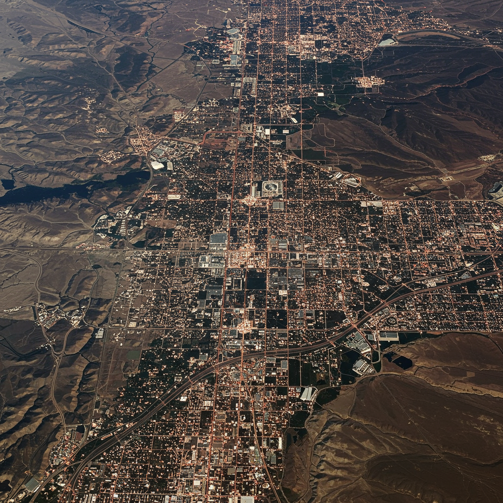
Las Vegas From Space: Witnessing 25 Years of Dramatic Growth
Satellite imagery provides a unique perspective on how our cities evolve over time. A striking example comes from the recently retired Landsat 7 satellite, whose final image captured the sprawling metropolis of Las Vegas, Nevada. Comparing this last shot, taken in May 2024, with one of the satellite’s very first images from July 1999, reveals the dramatic expansion of “Sin City” over the past quarter-century. The visual evidence suggests the Las Vegas metropolitan area has nearly doubled in size during Landsat 7’s operational lifespan.
This rapid urban growth is supported by population data. According to the U.S. Geological Survey (USGS), the population of the Las Vegas metro area surged from 1.38 million in 2000 to 2.33 million in 2023, an increase of approximately 69%. Projections estimate the population will reach 2.4 million by 2025, demonstrating sustained development.
The Satellite Behind the Story: Landsat 7’s Legacy
Landsat 7, a joint mission by NASA and the USGS, was a key component of the long-running Landsat program, which has been continuously capturing images of Earth’s surface since 1972. Launched on April 15, 1999, Landsat 7 orbited the planet every 99 minutes, capturing over 3.3 million images covering virtually every corner of the globe.
Originally designed for a five-year mission, the satellite far exceeded expectations, operating for 25 years despite facing a significant instrument failure in 2003 (which was later fixed). Its high-resolution imagery was particularly adept at monitoring urban areas and played a vital role in the development of modern mapping services like Google Maps. Landsat data has also provided unique perspectives on historical events, from the 9/11 terror attacks to Hurricane Katrina and the Deepwater Horizon oil spill.
On June 4, 2024, Landsat 7 received its final command, officially concluding its remarkable mission. Following a year-long decommissioning process to move it out of the path of other spacecraft, the satellite will now drift in space for around 55 years before eventually re-entering Earth’s atmosphere and burning up.
Beyond Urban Sprawl: Lake Mead’s Changing Face
The satellite images of the Las Vegas area also capture changes to nearby Lake Mead, the artificial reservoir formed by the Hoover Dam on the Colorado River. A notable difference between the 1999 and 2024 images is the apparent reduction in the lake’s size.
While increased water consumption in the rapidly growing region and the potential effects of human-caused climate change are factors often discussed in relation to Lake Mead’s water levels, it’s also important to note that the lake’s size naturally fluctuates season to season and year to year. NASA’s Earth Observatory points out that these natural variations make it challenging to attribute changes solely to anthropogenic factors based on satellite images alone without deeper analysis.
Visualizing Change: How Satellite Data Helps Us See History Unfold
The kind of long-term, consistent Earth observation data collected by missions like Landsat is invaluable. It provides the foundation for understanding large-scale environmental changes, urban expansion, and resource management. Services like Google Earth leverage this historical satellite and aerial imagery to create compelling visualizations.
Celebrating its 20th anniversary, Google Earth recently enhanced its features, making it an even better “time-travel machine.” Users can now explore historical Street View data integrated with 3D views and satellite imagery. Furthermore, curated timelapses using decades of satellite photos allow anyone to visualize significant changes in locations around the world, explicitly including examples showing the rapid urban growth of cities like Las Vegas and San Francisco. This demonstrates how the data from satellites like Landsat 7 directly enables us to see and understand decades of transformation on Earth’s surface.
The Evolving Landscape of Earth Observation
Landsat 7’s retirement comes at a time when Earth’s orbit is becoming increasingly populated. Beyond government missions, the number of active satellites has more than doubled in the last five years, largely due to the proliferation of commercial “megaconstellations” like SpaceX’s Starlink. Experts estimate there are now over 11,700 active satellites, with proposals potentially reaching over a million across various planned constellations.
While these commercial ventures aim to provide services like global internet access, this rapid growth raises concerns about space junk. Collisions between satellites and debris could create cascading fragments, posing a risk to future space operations. The need for careful decommissioning processes, like the one Landsat 7 underwent to move out of busy orbital paths, becomes increasingly critical in this crowded environment.
Today, the Landsat program continues its work with two operational satellites, Landsat 8 and Landsat 9. The planned future mission, Landsat Next, faces uncertainty regarding funding, highlighting the ongoing challenges and decisions required to continue monitoring our changing planet from space. Landsat 7’s final image of Las Vegas serves as a poignant reminder of the significant changes satellites have helped us track over the decades and underscores the importance of ongoing Earth observation efforts.