A colossal winter storm is rapidly descending upon the eastern two-thirds of the United States, poised to unleash a devastating combination of ice, heavy snow, and dangerously cold temperatures. With approximately 160 million people under various winter storm and cold weather alerts, residents from Texas and Oklahoma eastward through the South, Midwest, and Northeast are urged to prepare for potentially catastrophic impacts, including widespread power outages and treacherous travel conditions. This multi-day weather event, forecasted to begin on Friday, January 23, 2026, demands immediate vigilance and comprehensive preparedness.
Unleashing a Multi-Day Winter Assault Across the Nation
This formidable weather system is not merely a single-day event; it’s an unfolding drama expected to disrupt daily life for millions well into early next week. The sheer scale is staggering, encompassing a vast geographical area and threatening a diverse range of severe conditions. Forecasters are warning of extensive damage, which could rival the devastation caused by a hurricane in some areas, particularly due to the anticipated ice accumulation.
The storm’s trajectory is complex, starting its severe impact in the Southwest before sweeping across Texas, the Deep South, and the Tennessee Valley. From there, it will extend its reach into the Mid-Atlantic and Northeast. Citizens residing or traveling along the vital Interstate 40 and 20 corridors are specifically advised to ready themselves for the full brunt of winter weather.
A Treacherous Trajectory: From Texas to the Northeast
The impending storm promises a perilous journey across the country, beginning its assault on Friday, January 23, 2026, and continuing through the weekend. This powerful system is set to bring a “crippling ice storm” stretching from Central Texas through parts of the South, creating an exceptionally hazardous environment. Beyond the ice threat, up to a foot (30 centimeters) of snow is anticipated from Oklahoma eastward, affecting major metropolitan areas including Washington, D.C., New York, and Boston.
The Southern Front: Ice, Snow, and Power Grid Worries
The initial and most immediate threats will materialize across the Southern region, particularly in Texas and Oklahoma. Beginning Friday afternoon, a dangerous mix of snow and ice is expected to impact areas from Dallas, Texas, to Little Rock, Arkansas, and Oklahoma City, Oklahoma, by Friday evening. Temperatures are predicted to plummet dramatically by Saturday morning, with Dallas reaching 27°F and Oklahoma City dropping to a frigid 8°F.
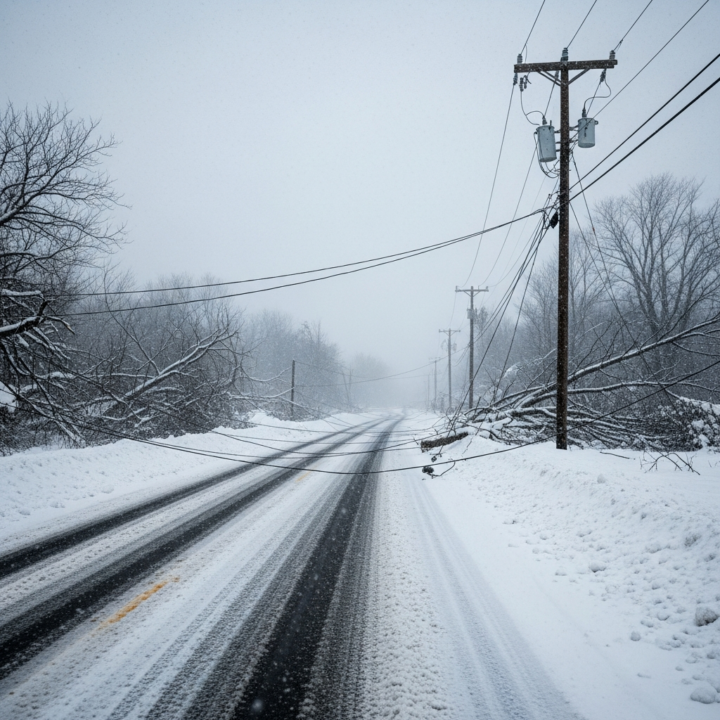
The danger of ice cannot be overstated. Accumulations are forecast to range from 0.1 to 0.25 inches, with localized areas potentially exceeding 0.5 inches of ice. This can add hundreds of pounds of weight to tree branches and power lines, making them highly susceptible to snapping, especially if combined with strong winds. This presents a grave risk for widespread, prolonged power outages that could last for days, leaving communities without electricity or heat.
High-risk zones for the worst of the ice include Dallas, Little Rock, Memphis, Nashville, the Atlanta area, Charlotte and Raleigh in North Carolina, and Washington, D.C. For Oklahoma, specific forecasts indicate snow accumulations of 8 inches or higher in northern and central parts of the state. Southern areas are expected to see lower snow amounts but significant sleet accumulations of 2 inches or more, compounding the travel dangers.
Five years ago, a severe cold snap caused a devastating failure of Texas’s power grid, resulting in millions without electricity and hundreds of fatalities. Mindful of this history, Texas Governor Greg Abbott has assured the public that the state’s power system is now “stronger” and prepared. Governors in Alabama, Arkansas, Georgia, Louisiana, Mississippi, Missouri, North Carolina, South Carolina, Tennessee, and Virginia have all declared states of emergency to facilitate response efforts, underscoring the severity of this approaching winter storm.
Midwestern Chill: Extreme Arctic Air Descends
Further north, the Midwest will experience an arctic blast from late Thursday into Friday. This cold air mass will bring dangerously low temperatures, exacerbated by strong winds, leading to life-threatening wind chills. By Friday morning, wind chills are forecast to reach extreme lows of minus 39°F in Minneapolis, minus 32°F in Chicago, and minus 39°F in Madison and Green Bay, Wisconsin. Such conditions make frostbite possible in as little as 10 minutes. In response to these hazardous wind chills, Chicago and Des Moines public schools, along with some Minnesota schools, have already announced closures.
Northeast on Alert: Snow, Ice, and Forecast Uncertainty
The Northeast will also feel the brutal cold by Friday night, with temperatures dropping below freezing in major cities like New York City and Philadelphia. The storm system itself is projected to reach the Northeast on Sunday, bringing a mix of snow and ice from Washington, D.C., through New York City, to Boston. While the threat is clear, meteorological models currently show some variations in predictions. The American model suggests heavy snow across much of the Interstate 95 corridor, whereas the European model indicates the rain/snow line will be further north, potentially leading to more ice than snow for New Jersey, Philadelphia, and Washington, D.C. Residents across the Northeast should closely monitor local forecasts as the storm approaches.
Dangerously Cold Temperatures to Follow
Regardless of whether an area receives snow, sleet, or ice, dangerously cold temperatures will inevitably follow the precipitation. A bitterly cold air mass is expected to settle over the affected regions, causing wind chills to plummet. Forecasted wind chills could reach as low as -50°F (-46°C) in parts of Minnesota and North Dakota, capable of causing frostbite in less than 10 minutes. Oklahoma, specifically, anticipates wind chills as low as -15°F, with northern parts of the state enduring a prolonged period of sub-freezing temperatures for at least 48 consecutive hours. An Extreme Cold Warning has been issued for Oklahoma, remaining active until Monday noon, highlighting the severe health risks posed by the relentless cold.
Widespread Disruptions and Precautionary Measures
This widespread winter storm is already causing significant disruptions and prompting extensive preparedness efforts from both authorities and residents.
Travel Nightmare Unfolds
Airlines have preemptively canceled hundreds of flights scheduled for Friday and Saturday at major airports, including Dallas, Atlanta, Oklahoma City, and Tulsa. Major carriers like American Airlines, Delta Air Lines, and United Airlines have issued travel alerts and are waiving rebooking fees for affected cities. Travelers should anticipate severe delays and cancellations across the country. Roadways, pretreated with salt brine in many areas like Oklahoma and Nashville, are still expected to become treacherous and remain icy well into the following week. Officials, including Virginia’s Governor, are strongly advising residents to avoid non-essential driving.
Community Preparedness in High Gear
States across the affected regions are taking extensive preparatory measures. Utility companies, such as those in Houston, have mobilized thousands of employees to manage potential outages. Governors in ten states have declared states of emergency, enabling quicker deployment of resources. In North Carolina, the largest public school system has instructed teachers to prepare three days’ worth of online or paper assignments, anticipating closures next week. Virginia’s Governor has urged residents to prepare for days without power or the ability to leave their neighborhoods. This concerted effort from officials underscores the serious nature of the approaching storm.
Preparing for the Worst: Essential Supplies Vanish
Anticipation of the storm’s impact has spurred a rush for emergency supplies. A power equipment store in Huntsville, Alabama, reported selling dozens of generators within a single day, with the vast majority of customer inquiries focused on backup power. In Dallas, grocery store shelves have been stripped bare, with essential items like water, eggs, milk, butter, and ground meat becoming unavailable as residents stock up. One resident from Toney, Alabama, wisely noted that she stocked up early, knowing that supplies like bread, gloves, candles, and hand warmers would be depleted by the weekend. This demand highlights the community’s proactive response to the looming threat.
Your Action Plan: Stay Safe During the Storm
Given the severe and multifaceted nature of this winter storm, proactive measures are paramount for safety.
Monitor Local Alerts: Stay continuously updated on local weather advisories, including Winter Storm Warnings and Extreme Cold Warnings, as forecasts can shift.
Secure Power & Heat: Charge all electronic devices. If you have a generator, ensure it’s fueled and operating correctly, but never use it indoors. Have alternative heating sources ready, such as extra blankets or sleeping bags.
Stock Emergency Kit: Gather a minimum of three days’ supply of non-perishable food, water (one gallon per person per day), medications, flashlights, batteries, a first-aid kit, and rock salt for walkways.
Protect Your Home: Insulate exposed pipes and consider dripping faucets to prevent freezing and bursting.
Avoid Travel: Check road conditions via resources like DriveTexas.org. Non-essential travel should be postponed until conditions improve significantly.
Dress Warmly: When venturing outdoors, dress in multiple layers, including a hat, gloves, and waterproof outerwear, to prevent frostbite and hypothermia. Limit outdoor exposure.
Check on Others: Reach out to elderly neighbors, those with medical conditions, or anyone who might need assistance.
Emergency Contacts: Know how to report power outages and always assume downed power lines are live.
Frequently Asked Questions
What makes this winter storm so dangerous, and which areas face the highest risk?
This winter storm is exceptionally dangerous due to its combination of crippling ice, heavy snow, and life-threatening arctic cold, impacting over 160 million people. The ice, particularly in Central Texas, the Deep South, and the Tennessee Valley, poses a significant risk for widespread and prolonged power outages as it adds immense weight to power lines and trees. Regions from Oklahoma eastward to the Mid-Atlantic and Northeast are expected to see heavy snow, while the Midwest will experience dangerously low wind chills. Specific cities at high risk for the worst ice include Dallas, Little Rock, Memphis, Nashville, Atlanta, Charlotte, Raleigh, and Washington D.C.
How long are extreme cold and hazardous conditions expected to last in affected regions?
The severe conditions are expected to begin on Friday, January 23, 2026, and persist through the weekend and into early next week. Many regions, especially northern Oklahoma, are forecast to experience sub-freezing temperatures for at least 48 consecutive hours. Dangerous wind chills, plummeting to as low as -50°F in parts of Minnesota and North Dakota, and -15°F in Oklahoma, are anticipated to last throughout the weekend and into Monday. Treacherous road conditions due to ice and snow are also expected to linger for several days after the precipitation subsides.
What critical supplies should I secure immediately to prepare for potential power outages?
To prepare for potential power outages, residents should immediately secure essential supplies. This includes a minimum three-day supply of non-perishable food and water (one gallon per person, per day). Crucially, have alternative light sources like flashlights and battery-powered lanterns, along with extra batteries. A portable charger for cell phones is vital. Ensure you have blankets, sleeping bags, or extra layers of warm clothing. Also, stock up on any necessary medications, a first-aid kit, and have a full tank of gas in your vehicle if it’s your only charging option. Consider purchasing rock salt for sidewalks if you live in an area prone to ice.
Conclusion
The approaching crippling winter storm represents a significant and multi-faceted threat to the eastern two-thirds of the United States. With forecasts indicating severe ice, heavy snow, and dangerously low temperatures, the potential for widespread power outages, travel disruptions, and health risks is high. By understanding the storm’s trajectory, regional impacts, and implementing robust preparedness measures, communities and individuals can significantly mitigate the dangers. Stay informed, remain vigilant, and prioritize safety above all else as this formidable winter storm unfolds.