A potentially historic winter storm is poised to unleash a devastating combination of heavy snow, thick ice, and brutal cold across nearly 30 U.S. states this upcoming weekend. Beginning Friday, January 23, 2026, this massive weather event will stretch from the Southern Plains across the South and up the East Coast, impacting over 200 million Americans. Forecasters warn of life-threatening conditions, widespread power outages, and severe travel disruptions. Understanding the storm’s dynamics and preparing now is crucial for safety and community resilience.
Unpacking the Looming Winter Storm: What to Expect
This significant winter storm is developing from a complex interaction of meteorological factors. A low-pressure system forming in the Southwest will draw in ample moisture from the Gulf of Mexico, while an influx of frigid Arctic air pushes southward. This collision will trigger precipitation in the southern Plains by Friday. As the system slowly tracks eastward, it will spread snow and accumulating ice. Further complicating matters, two upper-air disturbances are converging over America’s heartland. As this energy shifts, a new area of low pressure will emerge off the East Coast, intensifying the threat of heavy snow across the Northeast.
The Menace of Extreme Cold and Polar Vortex Impact
Beyond the snow and ice, one of the most dangerous elements of this winter storm is the extraordinary cold. The polar vortex, typically confined to the North Pole, is forecast to dip dramatically into the eastern half of the U.S. from Thursday through the first half of next week. This shift will send temperatures plummeting far below seasonal averages, potentially setting new record lows in many locations. Wind chill temperatures could feel as low as 40-50 degrees below zero in parts of the northern U.S. The extreme cold poses an immediate and severe health risk: frostbite can occur on exposed skin in a mere 5-10 minutes. Hypothermia is also a serious concern, making staying warm an absolute priority.
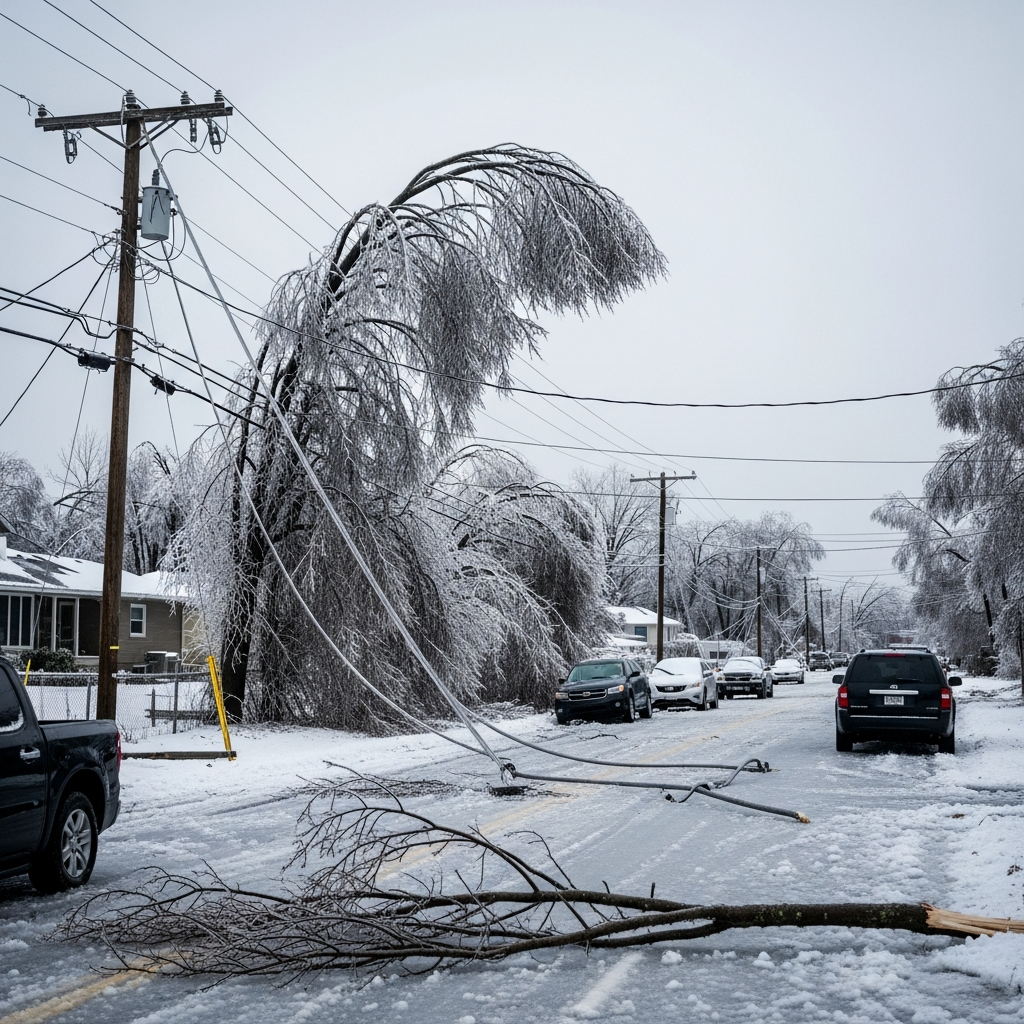
Catastrophic Ice Accumulation: A Major Threat
Ice accumulation is projected to be a critical and potentially catastrophic feature of this winter storm, especially along its southern track. While forecast models continue to refine predictions, accumulations between two-tenths of an inch to over half an an inch are expected in several areas. The Ark-La-Tex region, including Memphis, and parts of the Carolinas are identified as particularly vulnerable to these dangerous ice totals. Such substantial ice loads are heavy enough to bring down trees and power lines, leading to widespread and prolonged power outages. When combined with the brutally cold temperatures, a lack of indoor heating can quickly become a life-threatening situation, crippling affected communities and hampering recovery efforts for days.
Significant Snowfall Forecasts Across Millions
Snowfall totals are still fluctuating as forecast models converge, but significant accumulations are anticipated across a wide swath of the country. The southern Plains could see 5-10 inches of snow as the system initially develops from Friday into Saturday. As the storm moves east, specific amounts will vary, but parts of the Mid-Atlantic and Northeast are bracing for more than a foot of snow, particularly along the Interstate 95 and I-81 corridors. Washington D.C. could experience its first 12-inch snow event in a decade, while Oklahoma City faces the potential for one of its top five worst snowstorms on record. These heavy snowfalls will create extremely hazardous conditions, making travel nearly impossible in affected regions.
Widespread Travel Disruptions Anticipated
The approaching winter storm is expected to severely impact travel, both on roadways and at airports, across more than half of the United States. Road conditions will quickly deteriorate, becoming slick, icy, and potentially impassable. Major interstates such as I-10, I-20, I-30, I-35, I-40, I-44, I-49, I-55, I-81, and I-95 are all at risk for dangerous conditions. Officials strongly discourage non-essential travel throughout the weekend.
Airports in the South are particularly vulnerable to widespread cancellations and delays. Many facilities in this region lack the specialized de-icing equipment necessary for safe aircraft operations in icy conditions. Key airports that could experience significant disruptions include:
Dallas Fort Worth International Airport (DFW)
Will Rogers International Airport (OKC) in Oklahoma City
Clinton National Airport (LIT) in Little Rock, Arkansas
Memphis International Airport (MEM)
Nashville International Airport (BNA) in Tennessee
Hartsfield-Jackson Atlanta International Airport (ATL)
Travelers should monitor airline updates closely and be prepared for substantial changes to their plans.
Preparing for the Winter Storm: Essential Safety Measures
Given the severity of the forecast, proactive preparation is critical. Governors in states like North Carolina and South Carolina have already declared States of Emergency, mobilizing resources to prepare. Here are essential steps individuals and families should take:
Stay Informed: Monitor local weather alerts and official advisories. Forecasts can change rapidly, so staying updated is crucial.
Secure Homes: Insulate pipes, clear gutters, and ensure smoke and carbon monoxide detectors are working with fresh batteries.
Prepare for Power Outages: Charge all electronic devices. Have backup power sources (generators, battery banks) ready. Ensure you have alternative heating methods if safe to use indoors (e.g., propane heaters with proper ventilation).
Emergency Kit: Assemble a comprehensive winter storm kit. This should include:
Booster cables, a flashlight, and extra batteries
A shovel
Blankets and extra layers of warm clothing
Non-perishable food and water (at least a 3-day supply)
A first-aid kit and any necessary prescription medications
A fully charged cell phone and power bank
Matches or a lighter
Limit Exposure to Cold: If you must go outside, dress in layers, cover all exposed skin, and limit time outdoors to prevent frostbite and hypothermia.
Travel Safety: If travel is absolutely unavoidable, drive slowly, maintain extra distance between vehicles, and ensure your vehicle has a full tank of gas, good tires, and working lights. Carry your winter storm kit in your car.
Check on Neighbors: Elderly or vulnerable neighbors may need assistance during extreme weather.
The National Weather Service emphasizes that dangerous cold will linger after the storm passes, potentially prolonging the impact of ice and hindering recovery efforts. Community preparedness and mutual aid will be vital during this challenging period.
Frequently Asked Questions
What are the primary threats posed by this upcoming winter storm?
This significant winter storm, expected to begin on January 23, 2026, presents three primary dangers: heavy snowfall, particularly in the Southern Plains, Mid-Atlantic, and Northeast; catastrophic ice accumulation, especially in the South and Ark-La-Tex regions, threatening widespread power outages; and brutally cold temperatures, caused by a polar vortex dip, leading to wind chills of -40 to -50 degrees Fahrenheit and a high risk of frostbite and hypothermia. These combined threats make it a potentially life-threatening event across many states.
Which states and major cities are expected to be most impacted by this severe winter storm?
The storm is projected to impact nearly 30 states, stretching over 2,000 miles from the Southern Plains through the Mid-Atlantic and East Coast. Key regions include the Southern Plains, Ark-La-Tex, the South, Mid-Atlantic (e.g., Virginia, D.C.), and the Northeast (e.g., along the I-95/I-81 corridors). Major cities facing significant disruption include Dallas, Oklahoma City, Little Rock, Memphis, Nashville, Atlanta, Washington D.C., Houston, Charlotte, and Roanoke. Many airports in the South and major interstates across these regions are also expected to experience severe travel issues.
What essential steps should I take to prepare for the winter storm and ensure my safety?
To prepare for the winter storm, you should secure your home against cold and potential power outages, charge all electronic devices, and assemble a comprehensive emergency kit including non-perishable food, water, blankets, a first-aid kit, and warm clothing. Monitor local weather updates closely, avoid non-essential travel, and if you must drive, ensure your vehicle is prepared and carry an emergency kit. Finally, limit outdoor exposure due to extreme cold and check on vulnerable neighbors.
Conclusion
This impending winter storm is more than just a nuisance; it’s a critical weather event with the potential for widespread disruption and life-threatening conditions. With heavy snow, crippling ice, and extreme cold on the horizon for late January 2026, preparedness is paramount. By understanding the forecast, taking proactive safety measures, and staying informed through official channels, individuals and communities can mitigate risks and navigate this challenging period more safely. Your vigilance and readiness will make a significant difference in protecting lives and property.