Los Angeles County experienced a truly epic Christmas Eve, not with festive snow, but with a powerful atmospheric river storm delivering intense rainfall and widespread disruption. This “Pineapple Express” system, one of the most significant holiday storms in years, brought heavy downpours, especially in the morning hours, putting communities on edge from Altadena to Trabuco Creek and beyond. While rain began to taper off in many areas by Wednesday evening, residents were bracing for a second round expected on Christmas Day, with conditions remaining hazardous throughout the holiday week.
The Potent Atmospheric River Event Unfolds
The first wave of this potentially dangerous atmospheric river system slammed into Southern California on Wednesday, December 24, 2025. Characterized by a long, narrow band of moisture stretching across the Pacific, these storms are known for their ability to deliver vast amounts of precipitation. The National Weather Service (NWS) had issued extensive warnings, including flood watches for much of Southern California, with anticipations of rainfall rates exceeding one inch per hour during peak periods. Meteorologists noted the storm was unfolding as predicted, bringing not only torrential rain but also wind gusts over 60 mph in some areas, causing downed trees and power lines. The cumulative effect of sustained rainfall on already saturated ground heightened the risk, making even lighter showers capable of significant impact.
Tracking LA County’s Christmas Eve Rainfall Totals
The storm delivered substantial rainfall across Los Angeles County over a 24-hour span from Tuesday to Wednesday, with mountain and foothill areas often seeing the highest accumulations. By Wednesday night, some locations in the San Gabriel Mountains recorded astonishing totals over 11 inches, with San Gabriel Dam reporting 11.92 inches and Crystal Lake 11.3 inches.
Here are specific rainfall totals (in inches) from various LA County locations during this period:
Saugus: 4.18
Filmore: 4.10
Van Nuys: 3.87
Burbank: 3.45
Malibu: 3.05
El Monte: 2.82
San Dimas Dam: 2.45
Santa Monica: 2.42
Lancaster: 2.22
Hawthorne: 2.04
LAX: 1.90
Palmdale: 1.89
Long Beach: 1.58
Mount Wilson: 5.96 (as of 10 p.m. Tuesday)
Canoga Park: 4.29 (as of 10 p.m. Tuesday)
Bel Air: 3.09 (as of 10 p.m. Tuesday)
Beverly Hills: 2.60 (as of 10 p.m. Tuesday)
Downtown Los Angeles: 2.57 (as of 10 p.m. Tuesday)
These figures underscore the intensity and widespread nature of the Christmas Eve deluge, setting the stage for significant challenges across the region.
Widespread Impacts: Flooding, Mudslides & Closures
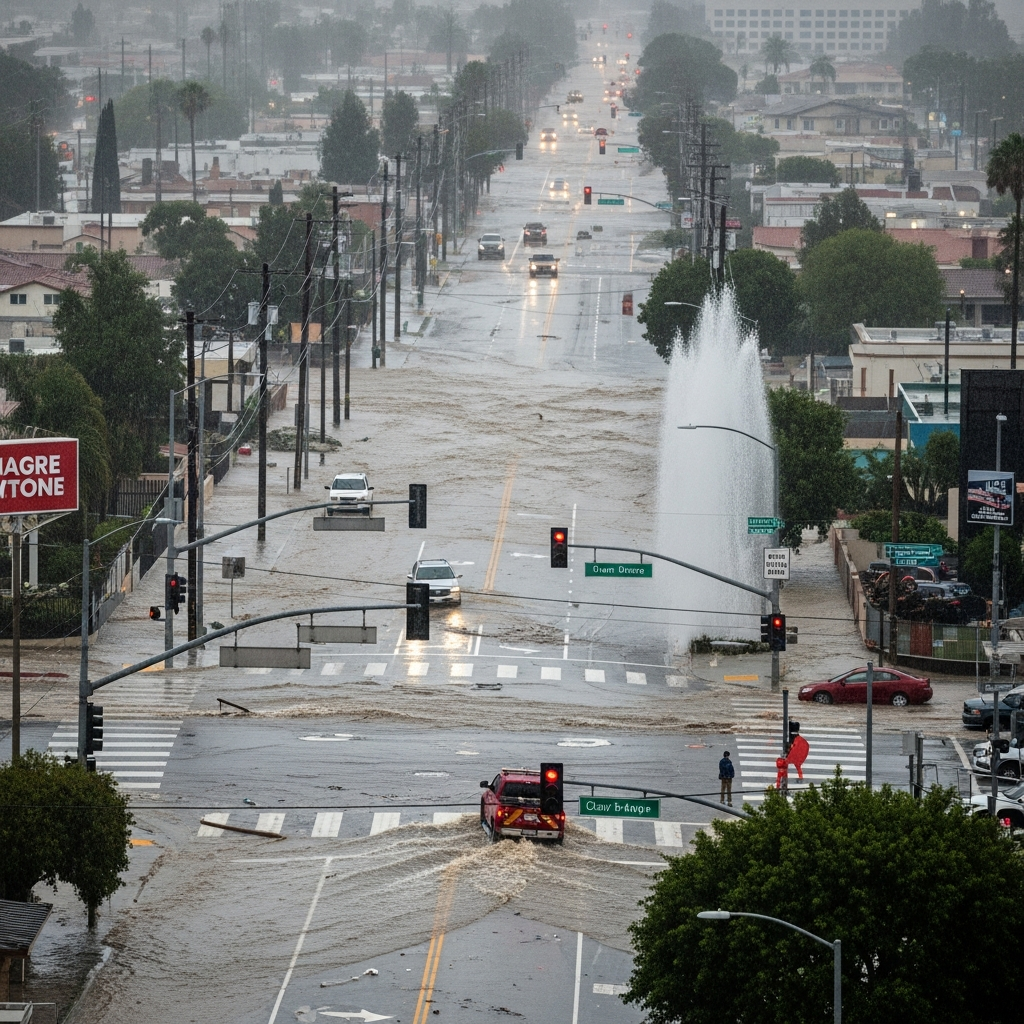
The intense downpours rapidly led to widespread flooding, dangerous mud and debris flows, and significant disruptions across Los Angeles County and beyond.
Burn Scar Vulnerability
Areas recently affected by wildfires proved particularly vulnerable. Burn scars from the Palisades, Eaton, Franklin, Kenneth, Agua, Owen, Sunset, Lidia, Hurst, and Bridge fires were highlighted as high-risk zones for mudslides and debris flows. Authorities issued Phase 2 mudflow forecasts for swathes of these areas, indicating a moderate to high likelihood of complete street blockages and potential threats to structures. Communities like Altadena and Wrightwood experienced notable mud and debris flows, with Wrightwood and Lytle Creek even being placed under shelter-in-place orders due to worsening conditions. In Lytle Creek, residents in the Happy Jack neighborhood became trapped after a bridge, their sole escape route, was covered and potentially destroyed by floodwaters.
Transportation Disruptions
Travel became a “nightmare” on Christmas Eve, with numerous road closures and SigAlerts. All lanes along the 5 Freeway at the Lankershim exit in Sun Valley were heavily flooded, forcing crews to shut them down and implement detours. While some lanes began to reopen around 5:20 p.m., other major arteries faced extended closures. Highway 14 was impacted by a rockslide, and Highway 2 near Wrightwood became impassable due to mud and water. Other significant closures included State Route 18 in Phelan, portions of U.S. 101, Angeles Crest Highway, California 27, 33, and 138. Malibu was particularly hard hit, with Tuna Canyon, Malibu Canyon, and Topanga Canyon Boulevard closing due to mud and debris flows, expected to remain closed for days. Caltrans strongly advised against unnecessary travel across affected routes.
Emergency Rescues and Evacuations
The dangers of the storm prompted numerous emergency responses and evacuations. In Palmdale, a group of people were rescued after their car became trapped in floodwaters. The Los Angeles Fire Department (LAFD) conducted multiple river rescues, including a dramatic helicopter rescue of a man, his dog, and cat from an RV stranded on a creek island. Another person was pulled from a drainage tunnel. The L.A. County Fire Department rescued a woman swept nine miles down San Jose Creek. Mandatory evacuation orders were issued for hundreds of residents in LA County burn scar areas, including parts of Pacific Palisades, Mandeville Canyon, and the Riverwood community in Sunland (due to a planned partial release from the Big Tujunga Dam). Los Angeles County Sheriff Robert Luna urged residents to heed these orders, prepare essential items, and plan for quick departure. The American Red Cross established evacuation centers in Monrovia, Palmdale, Stevenson Ranch, and Los Angeles, offering shelter, food, and even Christmas gifts for children.
Official Response & State of Emergency
In response to the severe threat, both state and local authorities rapidly mobilized. California Governor Gavin Newsom declared a state of emergency for Los Angeles, Orange, Riverside, San Bernardino, San Diego, and Shasta counties. This declaration allowed for the rapid mobilization of state resources, including fire engines, swiftwater rescue teams, helicopters, and over 300 personnel, with the potential deployment of the California National Guard. It also authorized Caltrans to seek federal assistance for road repairs. Los Angeles Mayor Karen Bass also issued a Declaration of Local Emergency, urging residents to stay home, remain vigilant, and detailing the extensive efforts by city teams for rescues, downed tree removal, and evacuation coordination. As of Wednesday evening, the Los Angeles Department of Water and Power (LADWP) was working to restore power to approximately 8,850 reported outages, with 32 downed power lines reported earlier.
Looking Ahead: The Lingering Storm Threat
While the heaviest downpour began to abate by Christmas Eve evening, the storm’s effects were far from over. Forecasts indicated 4-5 days of rain, with the potential for up to a foot of rain in the foothills and mountains and 4-8 inches in coastal and valley areas by Saturday. A subsequent storm was expected from Christmas Eve night into Christmas Day, bringing less than two inches of rain but still posing a significant risk of slides due to already saturated ground. Showers were expected to persist through Friday and Saturday, with conditions gradually drying out by the start of the following week. NWS flood watches were extended across Southern California, emphasizing the continued threat of widespread, life-threatening flooding, rockslides, and mudslides. Residents were advised to remain cautious and avoid unnecessary travel throughout the holiday period. This early-winter atmospheric river event follows a historically wet November, marking the wettest on record in some areas, contributing to a third-wettest rainy season on record for Southern California so far.
Tips for Residents During Severe Storms
Stay Informed: Monitor official weather alerts from the National Weather Service and local authorities.
Avoid Burn Scar Areas: If you live near or must travel through a burn scar area, be acutely aware of the risk of mud and debris flows. Heed all evacuation warnings and orders immediately.
Do Not Drive Through Floodwaters: Even shallow water can hide hazards or stall your vehicle. “Turn around, don’t drown.”
Prepare for Power Outages: Have flashlights, charged phones, and emergency supplies readily available.
Limit Unnecessary Travel: Stay home if possible to avoid hazardous road conditions and reduce strain on emergency services.
Secure Your Property: Use sandbags around vulnerable areas if advised by local officials.
- Have an Emergency Kit: Pack essential medications, important documents, and enough supplies for several days.
- www.nbclosangeles.com
- www.cbsnews.com
- deadline.com
- www.latimes.com
- www.usatoday.com
Frequently Asked Questions
How much rain fell in Los Angeles County on Christmas Eve and where were the highest totals recorded?
Los Angeles County experienced significant rainfall on Christmas Eve, December 24, 2025. While coastal and valley areas generally saw between 1.5 to 4 inches, mountain and foothill regions recorded much higher totals. The highest recorded amounts were in the San Gabriel Mountains, where San Gabriel Dam received an astonishing 11.92 inches and Crystal Lake saw 11.3 inches within a 24-hour span. Other notable totals included Saugus with 4.18 inches, Filmore with 4.10 inches, and Van Nuys with 3.87 inches.
What were the major impacts and areas affected by the Christmas Eve storm in Southern California?
The Christmas Eve atmospheric river storm caused widespread impacts, including significant flooding, dangerous mud and debris flows, and extensive road closures. Major freeways like the 5 Freeway in Sun Valley were shut down due to severe flooding. Burn scar areas from previous wildfires, such as Altadena, Wrightwood, and parts of Pacific Palisades, experienced mudslides and required evacuation warnings or orders. Emergency services conducted multiple swiftwater rescues, including a helicopter rescue in Palmdale and a nine-mile sweep rescue from San Jose Creek. Tragically, the storm also resulted in at least three confirmed storm-related fatalities across Southern California.
What precautions should residents take during and after severe atmospheric river events in Southern California?
Residents should prioritize safety by staying informed through official weather alerts and local emergency services. It is crucial to avoid driving through any standing water and to adhere immediately to all evacuation orders, especially if living near burn scar areas which are highly susceptible to mudslides and debris flows. Preparing an emergency kit with essentials like food, water, medications, and charged devices is advisable. Limiting non-essential travel and securing property with sandbags can also help mitigate risks during and after such powerful storm events.
The Christmas Eve storm served as a stark reminder of California’s vulnerability to extreme weather events, especially with atmospheric rivers becoming more frequent. The dedication of emergency crews, working tirelessly through the holiday, exemplified the region’s resilience. As Southern California moves through the lingering effects of this storm and prepares for future systems, ongoing vigilance and preparedness will remain crucial for the safety and well-being of its communities.