Hurricane Erin, a powerful Category 2 storm, brought significant and widespread coastal flooding to North Carolina’s Outer Banks before it pivoted away from the U.S. East Coast. This massive weather event, characterized by its unusually vast reach, caused substantial disruption and prompted critical safety warnings across multiple states. Its sheer size, with tropical-storm-force winds spanning over 600 miles in diameter, underscored the storm’s potential for broad impact even without making direct landfall. As the storm moved northeastward, it left a trail of high waters, strong winds, and treacherous ocean conditions in its wake, highlighting the enduring vulnerability of coastal communities.
Outer Banks Inundated as Erin Brushes Coast
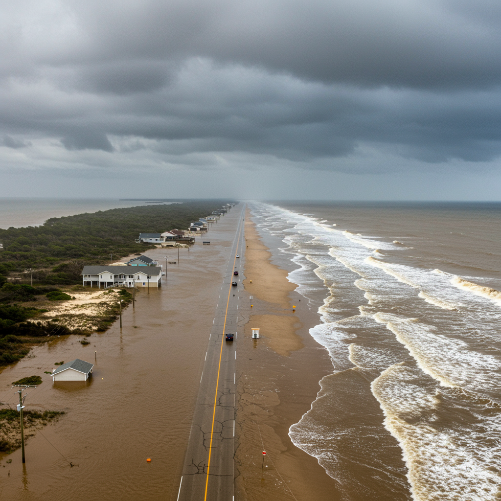
The initial brunt of Hurricane Erin’s fury was keenly felt across the Outer Banks. As of Thursday afternoon, the National Hurricane Center (NHC) confirmed Erin’s core was about 285 miles east of Cape Hatteras. The storm packed sustained winds nearing 100 miles per hour, alongside even higher gusts. This intense weather system generated heavy rainfall, a dangerous storm surge, and powerful rip currents. These conditions caused widespread coastal flooding in vulnerable areas like northern Buxton, Hatteras Village, and Ocracoke Island. Residents described experiencing “extreme ocean overwash” during the high tide cycles.
The surging waters created critical infrastructure challenges. Highway 12, a vital artery and the sole main road connecting parts of the Outer Banks, became impassable. Deep sand, water, and debris covered sections of the roadway, effectively cutting off access. Furthermore, the essential ferry service linking Ocracoke Island to the mainland was suspended. Melinda Meadows, a property manager at the Cape Hatteras Motel in Buxton, reported significant structural damage. Walls were ripped out, and crucial sand barriers disappeared. Despite these challenges, Tideland Electric Membership Corporation confirmed that Ocracoke Island maintained power throughout the storm, a testament to their infrastructure.
Urgent Warnings and Evacuation Efforts
In anticipation of Erin’s dangerous conditions, authorities issued stern warnings and evacuation orders. North Carolina Governor Josh Stein, on Wednesday, emphatically advised everyone to stay out of the ocean. He stressed the severe danger posed by high waves and powerful rip currents. Over 2,000 residents and vacationers on Ocracoke and Hatteras islands heeded these early evacuation calls, moving to safer ground.
A storm surge warning remained active from Cape Lookout to Duck, North Carolina. This indicated a life-threatening risk of coastal flooding from rising waters. The National Weather Service predicted an ongoing storm surge of up to four feet high in the Outer Banks through Thursday night. Additionally, a tropical storm warning covered the coastline from Beaufort Inlet, North Carolina, stretching up to Chincoteague, Virginia. Bermuda also received a tropical storm warning, underscoring the broad reach of Hurricane Erin. These alerts highlighted the immediate need for vigilance and adherence to official guidance.
Erin’s Trajectory and Broader East Coast Impact
While Hurricane Erin slowly moved away from the U.S. eastern seaboard, its influence extended far beyond North Carolina. Wind gusts reaching tropical storm force were expected across the mid-Atlantic and southern New England coast through early Friday. Forecasters also anticipated coastal flooding in other parts of the mid-Atlantic and Northeast as the storm continued its progression. Across East Coast beaches, from Florida to Maine, a high potential for dangerous rip currents persisted through Thursday. Swimmers received strong warnings to avoid entering the water.
The National Hurricane Center noted that Erin was accelerating northeastward. It moved across the western Atlantic, between the U.S. and Bermuda, throughout Friday. Forecasters predicted a gradual weakening of the storm over the next couple of days. By Saturday, Erin was expected to fall below the threshold for a tropical storm, eventually dissipating. This forecast offered a glimmer of relief after days of intense weather monitoring and preparations.
Coastal Resilience and Future Preparedness
For residents of the Outer Banks, experiencing hurricanes is an unfortunately common occurrence. As local Leslie Coleman remarked, the situation was “pretty par for the course,” though she acknowledged the higher waves and significant erosion of dunes. The barrier islands, inherently vulnerable, frequently face the wrath of Atlantic storms. This consistent exposure raises crucial questions about long-term coastal resilience and rebuilding strategies. Less than a year prior, North Carolina endured Hurricane Helene, a devastating storm in the western part of the state that claimed over 250 lives. While Erin’s immediate impacts differed, this recent history underscores the perpetual challenge of safeguarding communities against increasingly powerful and frequent weather events. Effective preparedness, robust infrastructure, and community awareness remain paramount for these exposed regions.
Frequently Asked Questions
What specific areas of the Outer Banks were most affected by Hurricane Erin’s flooding?
Hurricane Erin brought “extreme ocean overwash” and significant flooding to several key areas within the Outer Banks. These included northern Buxton, the northern sections of Hatteras Village, and northern Ocracoke Island. The National Weather Service issued a storm surge warning for the region from Cape Lookout to Duck, North Carolina, indicating a life-threatening risk from rising waters that reached up to four feet high in some places, particularly during high tide cycles.
How did Hurricane Erin impact travel and infrastructure in the Outer Banks?
Hurricane Erin severely disrupted travel and infrastructure. Highway 12, the primary road connecting parts of the Outer Banks, was cut off by deep sand, water, and debris, making it impassable. The critical ferry connection between Ocracoke Island and the mainland was also suspended. While some structural damage, like ripped-out walls at the Cape Hatteras Motel, occurred, Tideland Electric Membership Corporation confirmed that Ocracoke Island did not experience power loss due to the storm.
What safety precautions should residents and visitors take during a hurricane like Erin?
During a hurricane like Erin, residents and visitors must prioritize safety. North Carolina Governor Josh Stein explicitly warned everyone to stay out of the ocean due to high waves and powerful rip currents. Over 2,000 people on Ocracoke and Hatteras islands proactively followed evacuation orders. Adhering to all official warnings from the National Hurricane Center, National Weather Service, and local authorities is crucial, as conditions can change rapidly and unpredictably.
In conclusion, Hurricane Erin delivered a stark reminder of the power of nature, particularly for the resilient communities of North Carolina’s Outer Banks. While the storm is now weakening and moving away, its significant coastal flooding, road closures, and widespread rip current dangers underscored the necessity of robust emergency preparedness. Staying informed through official channels remains the best defense against such formidable weather events.