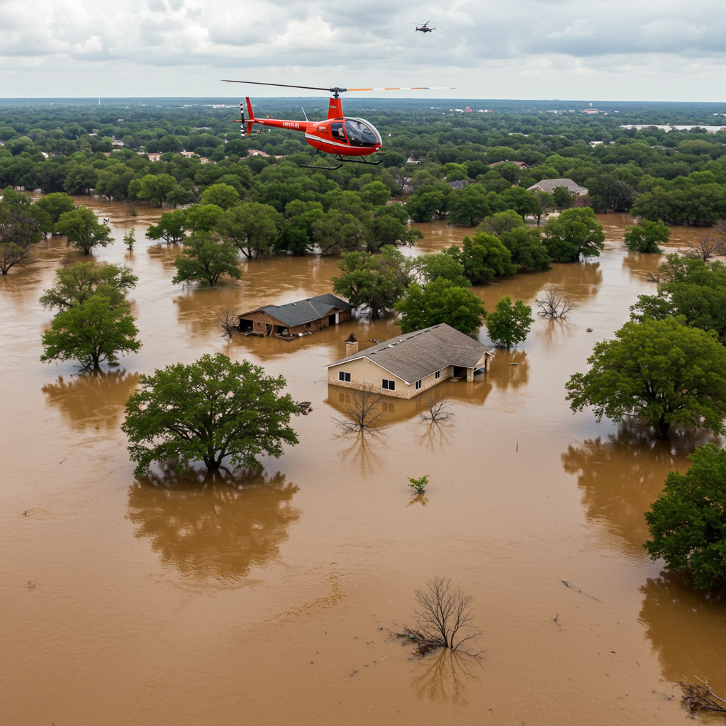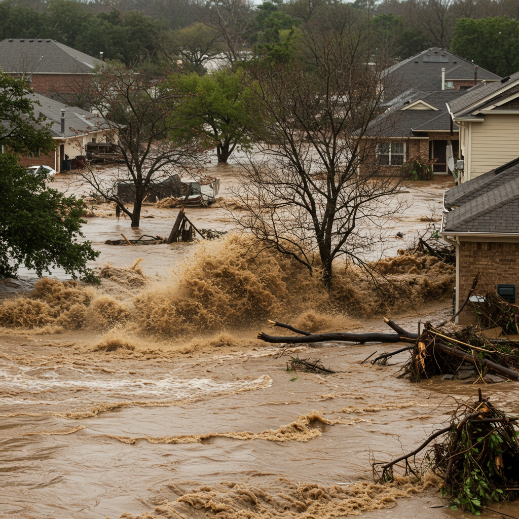
A devastating flash flood on the Guadalupe River in Texas claimed at least 27 lives and endangered hundreds at summer camps. The sheer speed and intensity of the rising waters caught many off guard. This tragedy has sparked a sharp debate. At the heart of the issue lies a fundamental question: Were officials adequately warned, or was this a genuinely unpredictable force of nature? The divergent views between state and local authorities and meteorological experts highlight critical challenges in disaster preparedness and interpreting severe weather threats.
Officials Claim Unforeseeable Speed
Following the tragic events in Kerr County, state and local officials voiced their perspective. They asserted that the speed and force of the Guadalupe River’s rise were beyond anything they could have anticipated. This unprecedented surge, they argue, made timely evacuations practically impossible and potentially more dangerous than staying put.
Governor Greg Abbott described the event as part of a pattern of “completely unpredictable” weather he had witnessed. Kerrville City Manager Dalton Rice recounted his experience early Friday morning. He saw only light rain along the river at 3:30 a.m. Yet, within just 90 minutes, returning to the same spot, he found a park area submerged under 20 to 25 feet of water. Rice narrowly avoided being trapped by the rapid inundation.
Kerr County Judge Rob Kelly echoed these sentiments. He stated emphatically that no one could have known this scale of flood was coming. Despite acknowledging the Guadalupe River valley as potentially the most dangerous in the United States, he maintained they had no prior reason to expect such a catastrophic event.
Officials also referenced the rainfall forecasts they received. W. Nim Kidd, chief of the Texas Division of Emergency Management, noted state leaders alerted local officials Thursday about potential flash flooding. Boat response teams were even mobilized as a precaution. However, Kidd stressed that the National Weather Service (NWS) forecast did not predict the actual amount of rain that fell. He stated forecasts had projected up to eight inches of rain, significantly less than what occurred.
Meteorologists Point to Clear warnings
Contrary to the officials’ claims, meteorologists contend that ample warning was provided. They argue the NWS issued timely alerts that should have prompted robust preparedness and action. Troy Kimmel, an Austin-based meteorologist specializing in emergency management, detailed the NWS communication timeline.
The NWS Austin-New Braunfels office issued a flash flood watch at 1:18 p.m. on Thursday. This bulletin explicitly advised people to monitor later forecasts. It also urged alertness for possible flood warnings. Crucially, it recommended that individuals in flood-prone areas be prepared to take action if flooding developed.
As rain intensified overnight, the situation escalated. Flash flood warnings for parts of the Hill Country began issuing at 11:41 p.m. Thursday. A specific warning for central Kerr County was issued at 1:14 a.m. Friday. This warning remained valid until 4:15 a.m. and contained stark language. It warned of “life-threatening flash flooding of creeks, streams, urban areas, highways, streets and underpasses.”
Kimmel acknowledged that the predicted rainfall totals fell short of the reality. However, he emphasized a critical point: “at the same time the watches and warnings were there.” He defended the NWS’s performance, stating they “did its job.” Kimmel concluded that officials’ assertion of unpredictability did not point to a failure in the forecast. Instead, it suggested a potential breakdown in their own emergency planning and response systems.
Analyzing the Discrepancy
The stark difference in perspective reveals a common challenge in disaster response. While meteorologists focus on the technical accuracy and timeliness of warnings, officials on the ground grapple with the practicalities of response. This includes assessing the severity of the threat, interpreting complex weather data, and making difficult decisions under pressure. The discrepancy likely stems from several factors.
One factor is the difference between predicting the potential for severe weather and predicting its exact location and intensity. Flash floods are notoriously rapid. They can occur with little lead time, especially in environments like the Hill Country with steep terrain and impermeable soil. While warnings signal the risk, the precise location and magnitude of the most intense rainfall can be hard to pinpoint far in advance.
Another factor involves the interpretation and dissemination of warnings. Was the language of the warnings fully understood by all receiving parties? Were local emergency plans adequately designed to respond to a “life-threatening” flash flood warning issued in the middle of the night? The meteorologist’s critique suggests that the existence of warnings, regardless of exact rainfall predictions, should have triggered specific, pre-defined actions. The officials’ surprise suggests either the warnings weren’t fully appreciated for their severity or the response protocols were insufficient for the speed of the event. Effective risk communication is paramount, ensuring warnings translate into appropriate action.
Camps and Evacuation Challenges
The presence of numerous summer camps along the river added a layer of complexity and vulnerability. Hundreds of children were at risk when the flood struck. Questions have naturally arisen about whether these camps had adequate evacuation plans and received timely notification.
State and local officials have not provided direct answers regarding the specific plans of individual camps. However, experts like Troy Kimmel are unequivocal on the necessity of such plans. Kimmel stated it would be “shocking” and “negligent” for any camp not to have a comprehensive emergency operations plan in place. This suggests a baseline expectation of preparedness for facilities housing vulnerable populations in hazardous areas.
Officials highlighted the difficult balance involved in ordering evacuations. Kerrville City Manager Dalton Rice discussed the “delicate balance” between ordering people to leave and potentially putting them on dangerous, flooded roads. He noted that mass evacuations could create “chaos” and risk people getting stuck. This dilemma is a real consideration in emergency management. However, it contrasts with the “life-threatening” nature described in the NWS warning. Kerr County Judge Ron Kelly, when asked directly about why camps weren’t evacuated, stated he could not provide an answer. This suggests a gap in clear responsibilities or documented procedures during the crisis.
Lessons for Future Preparedness
The Guadalupe River flash flood underscores critical lessons for communities in flood-prone regions. It highlights the vital importance of heeding weather warnings, even when exact rainfall totals are uncertain. A flash flood warning signifies imminent danger requiring immediate action.
Robust local emergency plans are essential. These plans must anticipate rapid-onset events like flash floods. They should outline clear procedures for notification, communication, and evacuation, particularly for vulnerable locations like schools, camps, and low-lying neighborhoods. Regular drills and updated protocols can improve response effectiveness.
Improving risk communication is also paramount. This involves ensuring that complex meteorological information is translated into clear, actionable guidance for emergency responders and the public. It also means building a culture of preparedness where residents and institutions in high-risk areas understand their vulnerability and the necessary steps to take when warnings are issued. Collaboration between weather services, emergency management agencies, and local entities, including summer camps, is key to saving lives during future severe weather events.
Frequently Asked Questions
What weather warnings were issued before the Guadalupe River flood?
The National Weather Service (NWS) issued a flash flood watch for the area at 1:18 p.m. on Thursday, advising preparedness. Flash flood warnings began issuing for parts of the Hill Country later that night, starting at 11:41 p.m. A specific, “life-threatening” flash flood warning for central Kerr County was issued at 1:14 a.m. Friday, remaining active until 4:15 a.m.
Why did officials and meteorologists disagree on the flood’s predictability?
Officials claimed the flood’s speed and intensity were unforeseeable and not fully predicted by rainfall forecasts (which they said projected up to 8 inches). They suggested evacuation was impractical or dangerous. Meteorologists argued that while exact rainfall wasn’t perfectly forecast, the issued flash flood warnings were clear indicators of “life-threatening” danger requiring immediate action, implying emergency plans should have accounted for such a possibility regardless of exact water levels or speed predictions.
What measures are crucial for safety in flash flood prone areas like Kerr County?
Key measures include actively monitoring official weather warnings, having well-established and practiced local emergency plans that include specific procedures for rapid-onset events like flash floods, and developing clear communication strategies to alert residents and institutions (like camps) quickly and effectively. Understanding local flood risks and having a personal or institutional evacuation plan is also vital.
The Guadalupe River flash flood was a devastating event with tragic consequences. The ensuing debate underscores the challenges inherent in preparing for and responding to the unpredictable nature of severe weather. While officials faced immense pressure, the event highlights the critical need for enhanced preparedness, clear communication, and robust emergency plans that anticipate the worst, guided by the best available meteorological information. Learning from this disaster is crucial for strengthening resilience in vulnerable communities.