As of Sunday, February 22, 2026, a potent and “potentially life-threatening” winter storm is rapidly intensifying, bringing blizzard warnings across New York City and the entire Tri-State area. Forecasters are predicting what could be the region’s most significant snowfall in a decade, with some areas bracing for over two feet of heavy, wet snow, dangerous winds, and widespread disruptions. This article provides critical real-time updates, detailed forecasts, and essential safety information to help residents prepare for and navigate this historic weather event. Authorities are urging everyone to finalize preparations immediately and avoid all unnecessary travel as conditions are set to deteriorate rapidly.
Understanding the Unprecedented Threat: A “Bomb Cyclone” Approaches
Meteorologists are describing this developing winter storm as an exceptionally rare and powerful “bomb cyclone” – a rapidly intensifying low-pressure system akin to a “winter hurricane.” This classification underscores the storm’s severity and its potential to deliver devastating impacts across New York, New Jersey, and Connecticut. Unlike a typical snowfall, this event is fueled by a unique convergence of energy from the Ohio Valley colliding with Gulf and ocean moisture, creating an intensely swirling weather pattern.
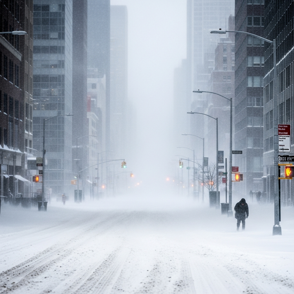
The National Weather Service has issued blizzard warnings for New York City, Long Island, coastal Connecticut, and much of New Jersey, effective from Sunday afternoon through Monday afternoon. Winter storm warnings are also in effect for interior regions. This marks New York City’s first blizzard warning since 2017, and for southern New England, it’s the first in four years, highlighting the extraordinary nature of this system. Expect not just heavy snow, but sustained winds of 35 mph or higher, leading to near-zero visibility and extremely hazardous conditions for over 10 to 12 consecutive hours.
Blizzard Timeline and Snowfall Projections
The storm’s progression means conditions will worsen quickly throughout Sunday and peak overnight. Here’s what to expect:
Saturday Evening (Feb 21): Quiet conditions, but clouds will steadily thicken across the region.
Sunday Morning (Feb 22): A few scattered rain or snow showers might appear, with temperatures initially hovering above freezing.
Sunday Midday: Visibility will begin to drop significantly as steadier snow develops, particularly for areas south and west of New York City.
Sunday Evening to Overnight: This is the critical period. The storm will rapidly intensify offshore, drawing heavy snow bands directly into the Tri-State area. Snowfall rates are projected to reach 2 to 3 inches per hour, and potentially over 3 inches per hour in localized areas. These intense bands could stall over certain locations for extended periods.
Monday Morning (Feb 23): Blizzard conditions will persist, making the morning commute “dangerous, if not impossible.”
Monday Afternoon: Snow will gradually taper off, though gusty winds and blowing snow will continue to impact visibility and travel.
Tuesday (Feb 24): Colder and breezy conditions are expected as cleanup efforts begin.
Wednesday: A weaker follow-up system is possible, but not expected to compare to this major event.
Expected Snow Totals Across the Tri-State Area:
The storm’s path suggests varying, but universally significant, snowfall amounts:
New York City (All Five Boroughs): Anticipated 17–19 inches, with localized areas potentially exceeding two feet.
Long Island: Projected 19–20 inches, with a “reasonable worst case” scenario suggesting over two feet.
Northeastern New Jersey: Expect 15–17 inches, with some higher totals possible.
Coastal Connecticut: Forecasts show 15–16 inches, with potential for locally higher amounts.
Southern Connecticut (Overall): 18 to 24 inches.
Northern Connecticut: 12 to 18 inches.
Interior Southern Connecticut & other Northeast NJ parts: Generally 10 to 15 inches.
Farther North and West (e.g., Poconos, Catskills): 8 to 12 inches due to less access to the storm’s core moisture.
Note: Any slight westward shift in the storm’s track could push these totals even higher, particularly for Connecticut.
Major Impacts and Risks
This powerful storm carries multiple significant hazards beyond just heavy snow. The combination of intense snowfall and high winds will create extremely dangerous conditions.
Damaging Winds and Power Outages
Winds will strengthen throughout Sunday, peaking overnight with gusts widely exceeding 40 mph across the entire region. Long Island, in particular, could see gusts up to 60 mph, while coastal Connecticut may experience gusts over 50 mph. These fierce winds, combined with the heavy, wet snow, pose an extreme risk for widespread power outages and downed trees. Residents should prepare for potential extended outages by having alternative heat sources, fully charged devices, and emergency kits ready.
Treacherous Travel Conditions
Travel will become increasingly hazardous as Sunday progresses.
Roads: Conditions will deteriorate rapidly Sunday evening, with whiteout conditions making travel “dangerous, if not impossible.” The Monday morning commute is expected to be severely impacted across the entire Tri-State area. Officials are strongly advising residents to stay off the roads unless it’s an absolute emergency.
Air Travel: Airlines have proactively canceled thousands of flights. American Airlines, Delta, and JetBlue have suspended operations at major Northeast airports including LaGuardia, JFK, Philadelphia, and Boston, with cancellations extending through Tuesday. Over 3,000 flights were canceled initially, a number expected to climb significantly. Many airlines have issued winter travel waivers, allowing changes without fees.
Rail Travel: Amtrak has also announced adjustments to some routes for Sunday and Monday due to the dangerous weather.
Coastal Flooding and Erosion
Beyond the snow and wind, coastal areas are vulnerable. Widespread minor to moderate coastal flooding is anticipated during high tide cycles from Sunday night into Monday morning. This could lead to localized overwash and dune erosion, particularly along the Jersey Shore, Long Island, and coastal Connecticut. Ocean waves are predicted to build up to 12–16 feet, further contributing to marine hazards.
Official Responses and Safety Directives
Government officials across the Tri-State area have enacted emergency measures, urging residents to take this Tri-State blizzard warning seriously.
New York: Governor Kathy Hochul declared a state of emergency for 22 counties, including all of NYC, and activated the National Guard for assistance. Mayor Zohran Mamdani announced “Code Blue” operations to protect the homeless and deployed over 700 salt spreaders and 2,000 garbage trucks converted into snowplows. NYC also issued a unique call for “emergency snow shovelers” to clear essential public areas, paying $19.14 per hour.
New Jersey: Governor Mikie Sherrill declared a state of emergency effective Sunday noon, advising residents to complete errands by Saturday and stay off roads Sunday and Monday. Paterson Public Schools have already announced closures for Monday.
Connecticut: Governor Ned Lamont activated the state’s Severe Cold Weather Protocol from Sunday noon to Tuesday noon. State agencies are coordinating with United Way 2-1-1 and local municipalities to ensure shelter and warming centers are available, offering transportation for those in need. Residents can call 2-1-1 or visit 211ct.org for assistance.
Philadelphia: Mayor Cherelle Parker declared a snow emergency and closed public schools for Monday, detailing preparations with 1,000 city personnel, 800+ pieces of equipment, and 25,000 tons of salt ready.
Essential Safety Reminders:
Stay Indoors: Avoid all unnecessary travel during the blizzard warning period.
Emergency Kit: Have a well-stocked emergency kit including flashlights, batteries, a first-aid kit, water, and a seven-day supply of medications.
Power Outages: Prepare for potential extended power outages. Do not use stoves or ovens to heat your home due to the risk of carbon monoxide poisoning. Discard perishable food if power is out for more than four hours.
Pets & Livestock: Bring pets indoors and secure livestock from the harsh elements.
Stay Informed: Continuously monitor official weather updates from the National Weather Service and local authorities (e.g., ct.gov/ctprepares).
- Help Others: Check on elderly neighbors and those who may need assistance. Share the 2-1-1 resource for shelter information.
- abc7ny.com
- www.nbcnews.com
- www.cbsnews.com
- www.fox5ny.com
- www.usatoday.com
This storm follows a late-last-month ice system that caused widespread impacts and tragically resulted in at least 50 deaths, including over 10 in New York City. Officials warn this current blizzard could bring even more hazardous conditions, emphasizing the need for extreme caution.
Frequently Asked Questions
What makes this Tri-State winter storm so severe, and how much snow is expected?
This winter storm, categorized as a “bomb cyclone” or “winter hurricane,” is exceptionally severe due to its rapid intensification and the unique convergence of atmospheric energy and moisture. This creates conditions for heavy, wet snow and powerful winds. The Tri-State area is largely expected to see 12 to 18 inches of snow, with localized totals potentially exceeding 24 inches in parts of Long Island, the Jersey Shore, and southern Connecticut. New York City specifically anticipates 17-19 inches, with higher amounts possible. Snowfall rates could reach 2-3 inches per hour, combined with wind gusts of 40-60 mph, leading to life-threatening whiteout conditions.
What official emergency measures are in place, and where can residents find help during the blizzard?
Governors in New York, New Jersey, and Connecticut have declared states of emergency, activating National Guard troops and deploying extensive resources. Connecticut has initiated a Severe Cold Weather Protocol, coordinating shelters and warming centers accessible by calling 2-1-1 or visiting 211ct.org. New York City has activated “Code Blue” for the homeless and deployed hundreds of snowplows and salt spreaders. Residents should follow local government advisories, stay informed via official state preparedness websites like ct.gov/ctprepares, and contact 2-1-1 for shelter or assistance needs if caught outside in dangerous conditions.
What should residents do to prepare for and stay safe during this powerful blizzard?
Residents should finalize all preparations by Saturday evening. Key actions include stocking an emergency kit with flashlights, batteries, water, and essential medications, and preparing for potential extended power outages by having alternative heat sources and fully charged devices. Avoid all unnecessary travel from Sunday evening through Monday, as road conditions will be impossible. Bring pets indoors, secure any outdoor items, and check on vulnerable neighbors. If experiencing a power outage, discard perishable food after four hours and never use stoves or ovens to heat your home due to carbon monoxide risks. Prioritize staying indoors and staying warm.
This powerful and rare winter event demands serious attention and preparedness from all residents across the Tri-State area. By understanding the forecast, taking proactive safety measures, and heeding official warnings, communities can collectively navigate this historic blizzard. Stay safe, stay warm, and prioritize the well-being of yourself and your neighbors as this storm unfolds.