tropical storm Chantal has formed rapidly off the southeast U.S. coast, now poised to bring significant heavy rain and potential flash flooding to the Carolinas. This developing situation prompted urgent tropical storm warnings for residents and visitors in coastal areas of both South carolina and North Carolina. The storm’s primary threat centers around drenching rainfall expected to persist into Monday. Authorities are urging caution and preparedness as Chantal makes its approach and eventual landfall.
Storm Status and Initial Impacts
As of Saturday night, July 5, 2025, Tropical Storm Chantal was situated roughly 65 miles (105 kilometers) east of Charleston, South Carolina. It was also about 120 miles (190 kilometers) south-southwest of Wilmington, North Carolina. The storm maintains maximum sustained winds clocked around 50 mph (85 kph). Chantal is currently moving northward at approximately 8 mph (13 kph). Rain bands from the storm were already spreading ashore over coastal sections.
Forecasts indicate little change in intensity before Chantal makes landfall. However, a swift weakening is anticipated once the storm moves inland over land. The National Hurricane Center (NHC) in Miami is closely monitoring the storm’s progression. They provide frequent updates as new data from U.S. Air Force crews become available.
Forecast Track and Landfall Timing
The storm’s center is expected to move over the coast of South Carolina overnight Saturday or early Sunday morning, July 6, 2025. Predictions from the NHC suggest landfall could occur anywhere between Charleston, South Carolina, and Cape Fear, North Carolina. Following landfall, Chantal is expected to track northeastward. Its path may take it over eastern North Carolina and southeastern Virginia. The storm is predicted to weaken significantly as it accelerates up the Eastern Seaboard early the following week. Rain bands and gusty winds could extend as far south as central Florida and as far north as coastal Virginia over the weekend.
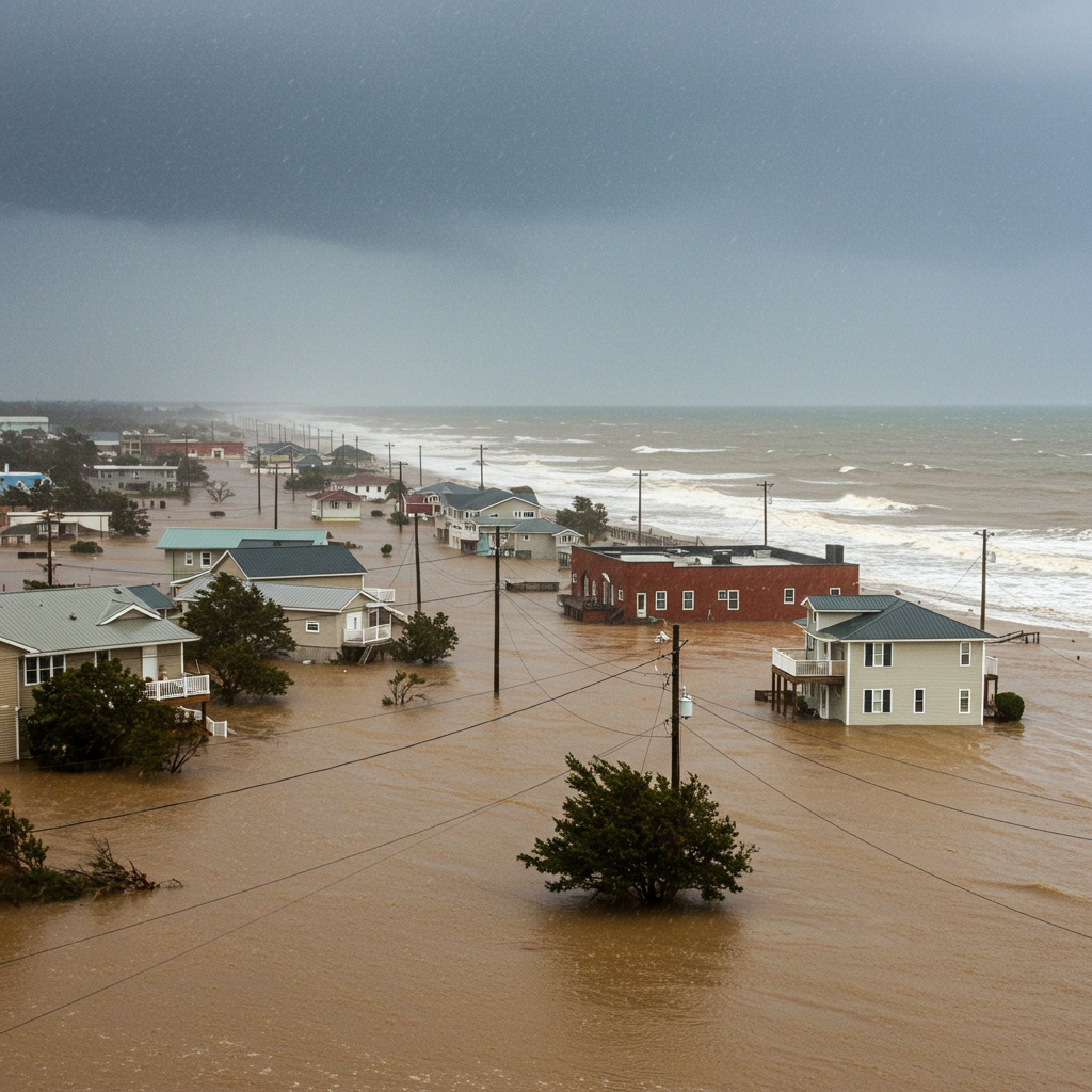
Heavy Rainfall and Flood Threat
The most significant concern associated with Tropical Storm Chantal is the potential for heavy rainfall. Forecasts call for widespread rain accumulations of 2 to 4 inches (5 to 10 centimeters) across the coastal plain of the Carolinas. These downpours are expected to continue through Monday, July 7, 2025. Isolated areas could see even higher amounts, potentially reaching up to 6 inches (15 centimeters) or more. This volume of rain raises significant concerns for flash flooding.
Flash flooding is a rapidly developing and dangerous situation. It poses risks, especially in urban, low-lying, or poorly drained areas. The National Weather Service (NWS) warns that such conditions can create hazardous travel, leading to slick roads and blinding downpours. Moderate flooding is considered possible in areas east of Interstate 95 in North Carolina. This could necessitate evacuations or rescues in affected locations. Drivers should exercise extreme caution and never attempt to drive or walk through water-covered roads. Bypassing road-closure signs in flooded areas is highly dangerous.
Additional Storm Hazards
Beyond heavy rain, Tropical Storm Chantal presents other hazards along the coast. Life-threatening rip currents are possible at beaches from northeastern Florida all the way up to the Mid-Atlantic states over the next few days. These powerful, fast-moving channels of water can be extremely dangerous for unsuspecting beachgoers. Swimmers caught in a rip current should swim parallel to the shore to escape it.
Minor coastal flooding is also expected in some areas, particularly south of Myrtle Beach, South Carolina. However, this is not currently seen as a major concern compared to the flash flood threat. Gusty winds are also anticipated. While the worst of Chantal’s winds are expected to remain offshore, wind gusts of 40 mph to 50 mph are possible near and east of where the storm makes landfall. Such winds could cause tree damage, localized power outages, and minor structural damage. Isolated tornadoes are also a risk across parts of eastern South Carolina and eastern North Carolina Saturday night into Sunday.
Warnings and Official Alerts
Due to the approaching storm and its expected impacts, authorities have issued specific warnings and watches. A Tropical Storm Warning is in effect for coastal areas stretching from the South Santee River in South Carolina northward to Surf City, North Carolina. This means tropical storm conditions are expected in these areas. A Tropical Storm Watch is also in effect from Edisto Beach, South Carolina, to the South Santee River, South Carolina. This indicates possible tropical storm conditions in the watch area.
The South Carolina Emergency Management Division (SCEMD) and the National Hurricane Center (NHC) are working closely with state and local teams. They are providing updated information and guidance to the public. Governor Henry McMaster has advised residents and visitors to pay close attention to forecasts and follow official guidance from emergency management agencies.
Chantal in Seasonal Context
Tropical Storm Chantal marks the third named storm of the 2025 Atlantic hurricane season. This season runs annually from June 1 to November 30. Peak activity typically occurs between mid-August and mid-October. Chantal’s formation comes as the season enters its traditionally busy period. NOAA (National Oceanic and Oceanic Administration) has predicted an “above-normal” Atlantic hurricane season for 2025. They give this outcome a 60% probability. Their forecast estimates the potential for between 13 and 19 named storms, including six to ten hurricanes and three to five major hurricanes. While Chantal is not expected to become a hurricane, its formation underscores the active nature of the current season.
Preparedness and Safety Advice
Residents and visitors in affected areas should take immediate steps to prepare for impacts from Chantal. Preparedness before a storm arrives is crucial. Delaying could be detrimental. Key steps recommended by emergency officials include:
Develop an Evacuation Plan: Identify your destination and route in case an evacuation is necessary.
Assemble Disaster Supplies: Create a kit with enough food, water, medicine, and other essentials for the storm and its aftermath.
Check Insurance Coverage: Ensure you have adequate coverage, especially flood insurance, which is often separate and has a 30-day waiting period.
Create a Communication Plan: Establish meeting places (including an out-of-town option) and how you will stay in touch with family members.
- Strengthen Your Home: Trim trees, install shutters or impact glass, and seal openings to protect your property.
- apnews.com
- www.npr.org
- www.cbsnews.com
- www.newsweek.com
- www.usatoday.com
Remember to avoid swimming in areas with dangerous rip currents. Always heed warnings about flooded roads and never attempt to drive or walk through standing water. Staying informed through official sources like the NHC, NWS, and local emergency management is paramount.
Frequently Asked Questions
What are the main risks from Tropical Storm Chantal in the Carolinas?
The primary threats from Tropical Storm Chantal include heavy rainfall, which could lead to significant flash flooding across the coastal plain. Forecasters predict 2 to 4 inches of rain, with isolated areas potentially receiving up to 6 inches. Other risks include dangerous rip currents along the coast, gusty winds that could cause minor damage, and a potential for isolated tornadoes in parts of eastern South Carolina and North Carolina.
What areas are under a tropical storm warning or watch for Chantal?
As Tropical Storm Chantal approaches, a Tropical Storm Warning is in effect from the South Santee River in South Carolina northward to Surf City, North Carolina. This means tropical storm conditions are expected. A Tropical Storm Watch covers the area from Edisto Beach to the South Santee River in South Carolina, indicating that tropical storm conditions are possible. Residents in these zones should prepare for impacts.
What safety steps should residents take for Tropical Storm Chantal?
Residents in the path of Chantal should finalize their preparations promptly. Essential steps include having a disaster supply kit ready, reviewing or creating an evacuation plan, ensuring adequate insurance (including flood insurance), and establishing a family communication plan. It is critical to stay off roads during heavy rain and avoid driving or walking through floodwaters. Heed all warnings from the National Hurricane Center and local emergency officials.
Tropical Storm Chantal is expected to make landfall soon. Its rapid formation and the forecast for heavy, flooding rains highlight the immediate threat to the Carolinas. Residents and visitors should monitor official weather updates closely and follow all guidance from the National Hurricane Center and local emergency management agencies. Staying vigilant and prepared is essential for safety during this event.