The world’s coral reefs, vital keystones of marine biodiversity, face an escalating crisis driven by climate change and local impacts. Monitoring their health and detecting subtle changes across vast, complex underwater landscapes presents significant challenges for scientists and conservationists. Traditional survey methods are often costly, time-consuming, and limited in their ability to capture the fine-scale detail needed for effective management. Addressing this data gap is crucial for understanding decline and identifying areas resilient to change.
Cutting-edge technology offers promising new avenues for tackling this critical need. Among these advancements, autonomous underwater vehicles (AUVs), commonly known as underwater drones, equipped with sophisticated vision systems, are proving to be powerful tools for marine environmental assessment. These robotic platforms can systematically explore underwater environments, collecting unprecedented amounts of detailed data that can inform conservation strategies and impact assessments.
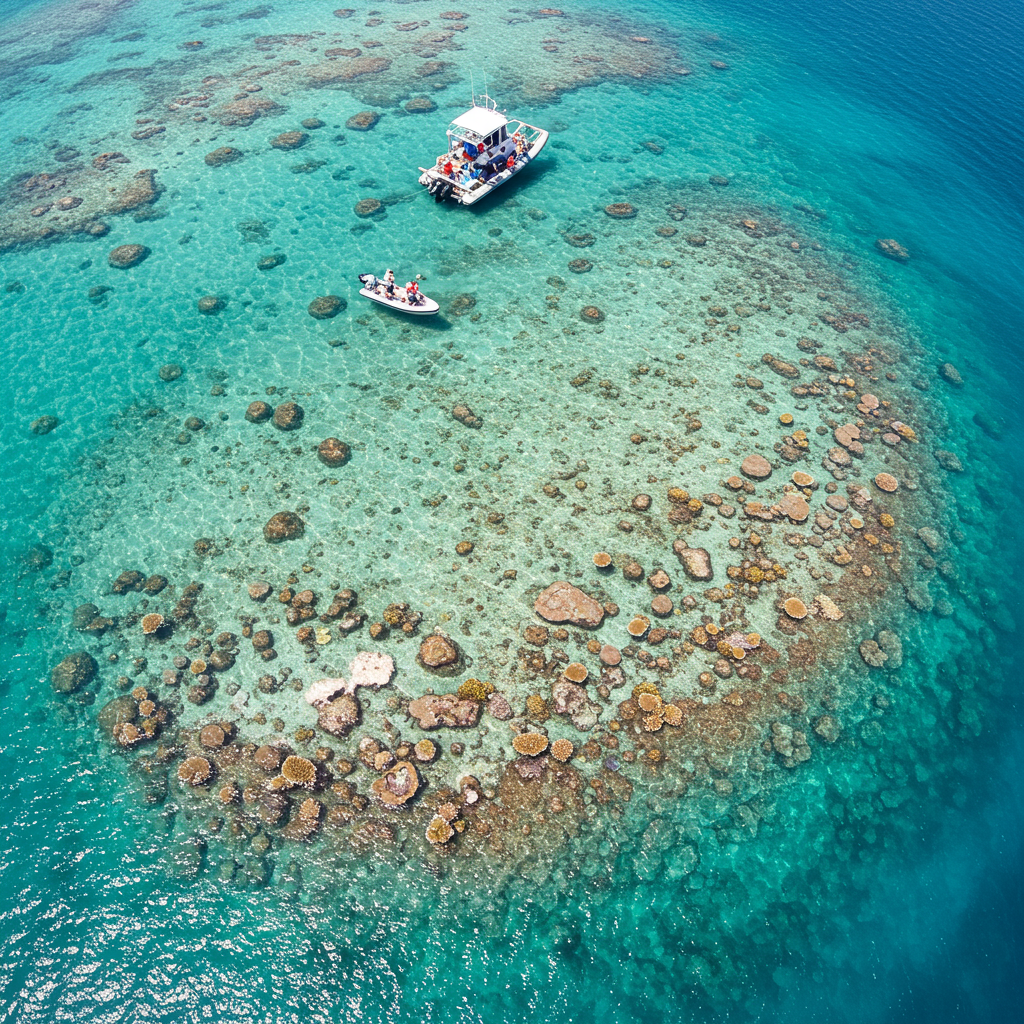
Autonomous Drones Investigate Reef Health Off Australia
A recent project off the coast of southwestern Australia exemplifies the potential of this technology. A collaborative team comprising Advanced Navigation, specialists in navigation and autonomous systems, and O2 Marine, a marine environmental and oceanographic consulting company, undertook a detailed survey of Hall Bank, a small, nearshore coral reef. Their goal was to leverage advanced autonomous technology to investigate environmental issues impacting the reef and demonstrate a more efficient and accurate monitoring approach.
For this mission, the team deployed three Hydrus drones, micro hovering AUVs developed and built by Advanced Navigation. These compact underwater vehicles are specifically designed for tasks requiring precision and detailed data capture, such as underwater surveys and inspections of delicate ecosystems like coral reefs. Equipped with high-resolution cameras and advanced sensors, the Hydrus drones can be programmed with specific navigation patterns, enabling them to traverse planned routes and collect systematic data.
Executing the Underwater Survey Mission
The mission involved programming the three Hydrus AUVs to execute coordinated transects and lawnmower survey patterns across designated sections of the Hall Bank reef. This systematic approach ensured comprehensive coverage of the target areas, collecting a high volume of visual data without manual pilot intervention during the survey phase.
A key challenge in underwater surveying is maintaining accurate position and orientation, as traditional GPS signals are unavailable below the surface. The Hydrus overcomes this using a sophisticated onboard Inertial Navigation System (INS) developed by Advanced Navigation. This INS utilizes ultra-sensitive sensors and complex algorithms to provide continuous, high-confidence state estimation. It dynamically adjusts its calculations based on the reliability of various sensor inputs, environmental conditions, and operational context, ensuring the drone follows its programmed path accurately, even in challenging underwater environments near complex reef structures. Each image and video frame captured is precisely geo-referenced, linking the visual data directly to its location on the reef – a capability difficult to achieve with less advanced methods.
Building a Digital Twin of the Reef
Once the drones completed their missions and were retrieved, the team transferred the collected data wirelessly via WiFi to an onshore facility. This data, consisting of high-resolution images and video, was then processed using specialized photogrammetry software, Agisoft Metashape. Photogrammetry transforms multiple 2D images captured from different angles into accurate 3D models.
By stitching together over 1,000 still images collected during the survey, the software created a detailed 3D digital twin of the surveyed reef area. This digital replica, developed at Advanced Navigation’s subsea robotics centre, allowed the research team to virtually explore the reef with unprecedented detail and accuracy.
Identifying Environmental Stressors
Analyzing the digital twin proved invaluable for identifying environmental issues affecting the Hall Bank reef. The high-resolution 3D model enabled the team to visualize and precisely locate evidence of coral distress and damage. This included identifying areas showing signs of coral bleaching, a stress response where corals expel the symbiotic algae living in their tissues, and fragmentation, which can result from storms, physical impacts, or disease.
The ability to detect these subtle yet critical changes in coral health across a detailed 3D representation provides a powerful diagnostic tool that complements or surpasses traditional in-situ observations. This detailed mapping capability is essential for tracking the progression of environmental issues and informing targeted conservation interventions.
Overcoming Technical Hurdles in Deep Blue
Deploying and operating autonomous systems in complex marine environments is not without challenges. The project team faced technical hurdles, particularly related to maintaining accurate positioning in areas where acoustic or other positioning signals were weak, especially near intricate coral structures. Balancing the desired level of survey resolution (how detailed the images needed to be) with the practical limitations of mission duration (how long the drone could operate underwater) also required meticulous pre-planning and optimization.
Environmental variables, such as unpredictable currents, posed another significant challenge by causing drift and potentially affecting consistent coverage and image quality. Addressing these issues necessitated careful mission planning, relying on the drone’s sophisticated navigation systems for real-time corrections, and post-processing techniques to ensure data integrity.
The Value Proposition for Marine Conservation
The successful Hall Bank survey demonstrates the significant advantages vision-assisted AUVs offer for marine environmental assessment. They provide a cost-effective method for collecting extensive, high-resolution, geo-referenced data over large areas, enabling detailed mapping of reef structure and health. This technology captures fine-scale changes in coral condition often missed by broader or less systematic survey methods.
For organizations like O2 Marine, integrating such advanced technology enhances their ability to conduct thorough environmental and sustainability analyses. This project served as a valuable demonstration of the Hydrus AUV’s capability, providing data and insights crucial for knowledge-sharing and future conservation efforts. Based on the positive results, O2 Marine plans to integrate the Hydrus technology into critical real-world projects and impact assessment investigations with its global partners, underscoring the technology’s practical value.
AI and Automation: Shaping the Future of Monitoring
This project aligns with a broader trend in marine science towards leveraging automation and artificial intelligence (AI) to overcome the limitations of manual monitoring. The global challenges facing coral reefs necessitate faster, more comprehensive data collection and analysis than ever before. The sheer volume and variety of data generated by modern sensors require automated processing solutions.
Deep learning, a subset of AI, is increasingly used to process large image datasets rapidly and accurately, classifying species, detecting damage, or quantifying habitat cover – tasks that would take human experts prohibitively long. While challenges like data quality, standardization, and the need for technical expertise remain, the potential for AI-facilitated automation to provide continuous, cost-effective information for adaptive management is immense. Projects like the Hall Bank survey are crucial steps in demonstrating the feasibility and benefits of these integrated technological approaches.
Frequently Asked Questions
What makes underwater drones suitable for monitoring coral reefs?
Underwater drones, or AUVs, designed for environmental surveys offer unique advantages. They can navigate complex reef structures safely, capture high-resolution, geo-referenced imagery systematically, and cover large areas more efficiently than human divers or towed systems. Advanced onboard navigation, like Inertial Navigation Systems (INS), is essential for accurate positioning underwater where GPS doesn’t work, ensuring data is tied to precise locations for mapping environmental issues like bleaching or fragmentation.
Who was involved in the Hall Bank coral reef survey project?
The Hall Bank survey was a collaborative effort. Advanced Navigation, a company specializing in navigation and autonomous systems (and developer of the Hydrus AUV), partnered with O2 Marine, a marine environmental and oceanographic consulting company. Advanced Navigation provided the technology and post-processing expertise, while O2 Marine brought the marine environmental assessment knowledge and identified the need for advanced monitoring.
How does creating a 3D digital twin help in assessing coral reef health?
Creating a 3D digital twin from collected images provides a detailed, spatially accurate replica of the reef. This allows researchers to virtually explore the reef, visualize its structure, and precisely map the location and extent of environmental issues like coral bleaching or physical damage (fragmentation). This level of detail and objective, persistent record is invaluable for tracking changes over time, conducting in-depth analysis, and presenting findings to stakeholders for conservation planning and impact assessment.
The Hall Bank project successfully demonstrated how vision-assisted underwater drones, coupled with advanced data processing techniques like photogrammetry, can provide a detailed and actionable understanding of coral reef health. By systematically mapping the reef and creating a high-resolution digital twin, the team effectively identified signs of environmental stress. As marine ecosystems continue to face threats, the integration of autonomous systems and AI-driven analysis will become increasingly vital tools for monitoring, research, and implementing effective conservation strategies worldwide.